
Toussidé | Pic Toussidé | Tarso Toussidé
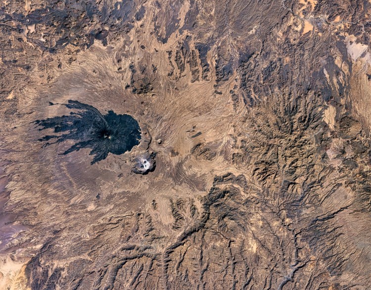
Toussidé—also known as Pic Toussidé or Tarso Toussidé—is a striking stratovolcano in northern Chad’s remote Tibesti Mountains. Surrounded by the Sahara Desert, the mountain is distinguished by its dark volcanic cone, extensive lava flows, fumarolic activity, and the extraordinary Trou au Natron caldera nearby.
🏔️ Overview
Toussidé rises from the western part of the Tibesti Mountains, an isolated Saharan mountain system extending across northern Chad and into southern Libya. The volcano forms part of the much larger Tarso Toussidé volcanic massif and is one of the most visually distinctive mountains in the Sahara.
Seen from space, Toussidé is especially dramatic. Dark lava and tephra spread outward from the volcano across the pale desert, producing a pattern that NASA has compared visually to spilled ink.
Toussidé is geologically young compared with much of the surrounding Tibesti volcanic landscape. Its sharply preserved cone and relatively uneroded lava flows indicate comparatively recent volcanic activity, although the exact dates of its eruptions remain uncertain.
⚡ Fast Facts
- Continent: Africa
- Country: Chad
- State/Province: Tibesti Region
- Region: Western Tibesti
- Mountain Range: Tibesti Mountains
- Mountain Type: Stratovolcano / composite volcano
- Parent Peak: Not consistently standardized in available topographic databases
- Elevation: 3,315 m (10,875 ft) in Peakbagger; other authoritative sources report approximately 3,265–3,299 m
- Prominence: 1,593 m (5,226 ft) in Peakbagger
- Isolation: Approximately 218.8 km (136 mi)
- Nearest Higher Neighbor (NHN): Tarso Emissi in the cited isolation dataset
- Volcanic Status: Potentially active; fumarolic activity has been observed
- Coordinates: Approximately 21.04° N, 16.47° E
Data note: Toussidé is a good example of why remote mountain elevations sometimes differ between databases. Peakbagger lists Pic Toussidé at 3,315 meters, while the Smithsonian Global Volcanism Program currently gives 3,299 meters and NASA has cited 3,265 meters. The prominence figure of 1,593 meters is based on Peakbagger’s topographic dataset.
📍 Location
Toussidé is located in the western Tibesti Mountains of northern Chad, deep within the central Sahara.
The Tibesti form one of the Sahara’s largest and highest mountain regions. Their volcanic plateaus, calderas, lava fields, rocky peaks, and deeply eroded valleys rise dramatically above the surrounding desert.
Toussidé lies roughly west of the central portion of the Tibesti massif. Bardaï, the principal settlement in the Tibesti Region, is well to the east, while the oasis settlement of Zouar lies farther south.
Unlike mountains located near established trekking centers, Toussidé occupies extraordinarily remote terrain. There are no maintained recreational trail networks, mountain huts, rescue infrastructure, or easy road access comparable with more frequently climbed mountains.
📏 Elevation & Prominence
Toussidé’s exact summit elevation varies depending on the mapping dataset used.
Peakbagger records:
- Elevation: 3,315 m (10,875 ft)
- Prominence: 1,593 m (5,226 ft)
- Isolation: about 218.8 km (136 mi)
The Smithsonian Global Volcanism Program currently lists an elevation of 3,299 meters (10,823 feet), while NASA and other scientific sources have commonly used 3,265 meters (10,712 feet).
Regardless of the precise elevation adopted, Toussidé is one of the highest and most prominent mountains of the Tibesti.
Its prominence exceeding 1,500 meters also qualifies Toussidé as an ultra-prominent peak, making it one of the comparatively small number of African mountains that meet this threshold.
🪨 Geology
Toussidé belongs to the Tibesti Volcanic Province, one of Africa’s major intracontinental volcanic regions.
Volcanism in the Tibesti developed over older Precambrian crystalline basement and Paleozoic sedimentary rocks. Activity occurred over millions of years, producing enormous volcanic shields, plateaus, lava fields, calderas, pyroclastic deposits, and smaller cones.
Pic Toussidé represents one of the youngest stages of this long volcanic history.
The volcano is composed of material including:
- Lava
- Scoria
- Lapilli
- Ash and other tephra
- Pyroclastic deposits
Its lava flows are particularly impressive. Some extend approximately 25 kilometers (16 miles) from the volcano and collectively cover around 200 square kilometers (77 square miles).
Many remain dark and relatively little eroded. This contrasts dramatically with the lighter desert surface surrounding the volcano.
Toussidé is also associated with a complex system of older volcanic depressions. The volcano developed along the western margin of the older Yirrigué, or pre-Toussidé, caldera system.
Trou au Natron
Immediately southeast of Toussidé is one of the region’s most remarkable geological features: Trou au Natron.
This large volcanic depression is roughly 8 kilometers across and reaches hundreds of meters below its rim. Its pale floor contrasts sharply with Toussidé’s dark volcanic terrain.
Mineral deposits left behind by evaporating water give parts of the caldera floor a brilliant white appearance.
The contrast between black lava, reddish-brown desert rock, and white mineral deposits makes the Toussidé–Trou au Natron complex especially spectacular in satellite photographs.
Is Toussidé Still Active?
Toussidé is considered potentially active, but its eruptive history is poorly constrained.
The Smithsonian Global Volcanism Program does not currently identify a confirmed Holocene eruption for Tarso Toussidé. This is important because older accounts sometimes give precise historical eruption dates that are not supported by the current Smithsonian record.
Nevertheless, fumaroles have been documented around Pic Toussidé. These vents release heated gases and provide evidence that geothermal activity persists beneath the mountain.
🌿 Flora & Fauna
The Tibesti may lie within the Sahara, but its higher elevations create environments considerably different from the surrounding low desert.
Vegetation across most of Toussidé is extremely sparse. Rocky volcanic ground, low rainfall, intense sunlight, and large daily temperature variations create difficult growing conditions.
Moisture associated with fumaroles and sheltered depressions can create small localized habitats where plants survive in otherwise exceptionally dry terrain.
The broader Tibesti Mountains also support desert-adapted wildlife. Species associated with the region include Barbary sheep and a variety of small mammals, reptiles, and birds capable of surviving in rocky Saharan environments.
These mountain habitats function almost like ecological islands surrounded by lower, hotter desert.
🥾 Hiking & Climbing Routes
Toussidé should not be approached as a conventional hiking destination.
There is no established tourist summit trail comparable with those found on Kilimanjaro, Mount Kenya, or many European and North American mountains. Reaching the mountain involves an expedition through an extremely isolated desert environment.
Challenges include:
- Very limited water
- Extreme remoteness
- Rough volcanic terrain
- Difficult navigation
- Long distances between settlements
- Limited communications
- Minimal emergency medical infrastructure
- Extreme daytime and nighttime temperature differences
- Potential security hazards
The rough surfaces of Toussidé’s lava flows can also make travel surprisingly slow.
Most historical exploration of the region has involved scientific expeditions, specialist desert travelers, and carefully organized overland journeys rather than ordinary recreational hikers.
🏔️ Field Guide Tip: Toussidé is currently better regarded as a mountain to study than a destination to independently climb. As of August 2026, the U.S. State Department lists Chad at Level 4 — Do Not Travel. Anyone researching a future expedition should check current government travel advisories before making plans.
For general remote-hiking preparation, see The Ten Essentials for Hiking.
🌤️ Best Time to Visit
There is currently no responsible conventional tourist season to recommend for Toussidé because security conditions take priority over weather considerations.
From a purely climatic standpoint, the cooler part of the Saharan year would generally present less severe heat than summer. High elevations in the Tibesti can also become surprisingly cold, particularly at night.
Future visitors would need to prepare for:
- Powerful sun
- Very dry air
- Cold nights
- Strong winds
- Dust and blowing sand
- Large temperature swings
- Little or no dependable surface water
Anyone considering the region in the future should first verify that official travel advice and local security conditions allow safe access.
🧭 Nearby Mountains & Attractions
Emi Koussi
The great Emi Koussi rises in another part of the Tibesti and is the highest mountain in Chad and the Sahara.
Like Toussidé, Emi Koussi is volcanic, but its enormous shield-like form differs substantially from Toussidé’s steep summit cone.
Trou au Natron
Trou au Natron lies immediately southeast of Toussidé and is arguably the volcano’s most remarkable companion feature.
Its enormous crater walls, pale mineral-covered floor, volcanic cones, and association with former lakes make it an important location for understanding both the volcanic and climatic history of the Sahara.
💡 Fun Facts
- Toussidé is an ultra-prominent mountain. Its prominence exceeds the 1,500-meter threshold used to define an “Ultra.”
- Its dark lava flows can easily be seen from space. Satellite imagery makes Toussidé one of the Tibesti’s most recognizable volcanoes.
- Some lava flows extend roughly 25 kilometers from the volcano.
- The Smithsonian does not currently record a confirmed Holocene eruption, despite Toussidé’s youthful appearance.
- Fumaroles still occur around the volcano, demonstrating continued geothermal activity.
- Trou au Natron once held substantially more water. Today, pale evaporite deposits cover parts of its floor.
- Toussidé is one of several major volcanic centers that make the Tibesti Mountains one of the most geologically fascinating regions of the Sahara.
❓ Frequently Asked Questions
Where is Toussidé?
Toussidé is located in the western Tibesti Mountains of northern Chad, in the central Sahara Desert.
How high is Toussidé?
The exact figure varies by source. Peakbagger lists 3,315 meters (10,875 feet), the Smithsonian Global Volcanism Program gives 3,299 meters (10,823 feet), and NASA has cited 3,265 meters (10,712 feet).
What is Toussidé’s prominence?
Peakbagger lists a topographic prominence of approximately 1,593 meters (5,226 feet).
What is Toussidé’s isolation?
Its topographic isolation is approximately 218.8 kilometers (136 miles).
What is the nearest higher neighbor of Toussidé?
The isolation dataset associated with the approximately 218.8-kilometer figure identifies Tarso Emissi as the nearest higher terrain. Mountain names and elevations in this remote part of the Tibesti vary between mapping datasets, so older references may instead point readers toward Emi Koussi as the next major higher summit.
Is Toussidé an active volcano?
Toussidé is generally regarded as potentially active. Fumarolic activity has been observed, although the Smithsonian Global Volcanism Program does not currently identify a confirmed Holocene eruption.
When did Toussidé last erupt?
There is no securely established date for its most recent eruption. The young appearance of its lava and volcanic deposits indicates relatively recent geological activity, but precise historical eruption dates sometimes repeated online should be treated cautiously.
Can you climb Toussidé?
A physical ascent is possible for suitably equipped expeditions, but Toussidé is not an established recreational climbing destination. Access is exceptionally difficult, and current government travel advisories warn against travel to Chad.
What is Trou au Natron?
Trou au Natron is a large volcanic caldera southeast of Toussidé. Its floor contains striking pale mineral deposits and evidence that it held a lake during wetter phases of Saharan history.
Is Toussidé the highest mountain in Chad?
No. Emi Koussi is higher and is both Chad’s highest mountain and the highest summit in the Sahara.
🔗 Related Articles
- Emi Koussi
- Tibesti Mountains
- Africa Mountains
- Ahaggar Mountains: Mount Tahat, Geology, Wildlife & Travel Guide
- The Ten Essentials for Hiking
📚 Sources
- Smithsonian Institution — Global Volcanism Program: Tarso Toussidé — volcanic classification, elevation, morphology, rock types, and eruption record.
- NASA Earth Observatory — Tarso Toussidé Volcano, Northern Chad — satellite imagery and evidence for youthful lava, tephra, and caldera features.
- Peakbagger — Ultras of North, West, and Southern Africa — elevation and prominence data for Pic Toussidé.
- Permenter & Oppenheimer — Volcanoes of the Tibesti Massif (Chad, Northern Africa) — scientific overview of the Tibesti Volcanic Province and the development of Pic Toussidé.
- Wikipedia — Tarso Toussidé — cross-check for prominence, isolation, and the Tarso Emissi isolation relationship.
- U.S. Department of State — Chad Travel Advisory — current official travel and security guidance.




