
Miller Peak
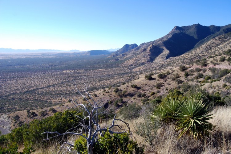
Miller Peak is the highest summit in Arizona’s Huachuca Mountains, rising to about 9,468 feet in southeastern Arizona near Sierra Vista and the U.S.–Mexico border. Its combination of high elevation, dramatic topographic prominence, wilderness surroundings, and far-reaching views makes it one of southern Arizona’s most significant mountain summits.
The peak stands within Coronado National Forest and the 20,190-acre Miller Peak Wilderness. From the summit and high ridges, hikers can look across the desert basins and isolated mountain ranges of southeastern Arizona, south toward Mexico, and east toward the Chiricahua Mountains.
⚡ Fast Facts
| Feature | Details |
|---|---|
| Country | United States |
| State | Arizona |
| County | Cochise County |
| Mountain Range | Huachuca Mountains |
| Elevation | 9,468 feet / 2,886 meters |
| Prominence | 5,008 feet / 1,526 meters |
| Isolation | 66.45 miles / 106.95 kilometers |
| Nearest Higher Neighbor (NHN) | Chiricahua Peak |
| Land Management | Coronado National Forest |
| Wilderness Area | Miller Peak Wilderness |
| USGS Topographic Map | Miller Peak |
| Coordinates | 31.39282° N, 110.29291° W |
| Main Hiking Access | Crest Trail #103 and connecting summit trail |
| Best Seasons | Spring, fall, and suitable winter days |
Peakbagger’s LiDAR-based data places the summit at 9,467.8 feet, with 5,008 feet of clean prominence and 66.45 miles of isolation. That prominence ranks Miller Peak among the most topographically prominent mountains in Arizona.
🏔️ Highest Point of the Huachuca Mountains
Miller Peak forms the roof of the Huachuca Mountains, a rugged range that rises sharply above the grasslands and desert basins of southeastern Arizona.
Although the summit is slightly lower than several of Arizona’s better-known high peaks, Miller Peak possesses exceptional prominence. More than 5,000 vertical feet separate its summit from the key saddle connecting it to higher terrain, giving the mountain a much more imposing geographic presence than its elevation alone suggests.
The summit is also the highest point in Miller Peak Wilderness and one of the dominant summits of southeastern Arizona.
Nearby mountains include Carr Peak, which rises along the same Huachuca crest, while Mount Wrightson dominates the Santa Rita Mountains farther northwest.
🧭 Nearest Higher Neighbor: Chiricahua Peak
Miller Peak’s Nearest Higher Neighbor is Chiricahua Peak, located roughly 66 miles to the east-northeast in Arizona’s Chiricahua Mountains.
This unusually large distance to higher terrain explains Miller Peak’s impressive isolation. For more than 60 miles in every direction, no summit rises higher.
Chiricahua Peak reaches approximately 9,776 feet, just a few hundred feet higher than Miller Peak, but broad desert basins and multiple mountain ranges separate the two summits.

🌄 Miller Peak Wilderness
Miller Peak lies within the federally designated Miller Peak Wilderness, established in 1984 and covering approximately 20,190 acres.
The wilderness occupies the southern portion of the Huachuca Mountains between Sierra Vista and the Mexican border. The U.S. Forest Service describes the landscape as a rugged combination of soaring summits, cliffs, and deep canyons.
More than 20 trails enter or cross the wilderness, creating a surprisingly extensive trail system despite the area’s rugged character. The Arizona National Scenic Trail also passes through the wilderness on its way toward its southern terminus at the international border.
Because this is designated wilderness, motorized and mechanized transportation is prohibited. That includes bicycles as well as motor vehicles and drones.
🥾 Hiking Miller Peak
Miller Peak can be reached from several directions, making it possible to build anything from a demanding day hike to a longer backpacking trip.
One of the best-known approaches begins at Montezuma Pass and follows Crest Trail #103 north along the spine of the Huachuca Mountains.
The Crest Trail runs for approximately 11 miles along the high ridges of the range. A spur from the crest provides access to Miller Peak’s summit. The trail also connects with routes leading toward Ramsey Peak, Pat Scott Peak, Carr Canyon, and other areas of the mountains.
The Forest Service identifies several major access areas for Miller Peak Wilderness, including:
- Upper Carr Canyon via Forest Road 368
- Miller Canyon via Forest Road 56
- Montezuma Pass and the southern Huachucas via Forest Roads 61 and 771
These different access points allow hikers to choose routes of varying length and difficulty.
🥾 Montezuma Pass and Crest Trail #103
For hikers interested in experiencing the high spine of the Huachuca Mountains, the route from Montezuma Pass is particularly rewarding.
The trail begins near the top of Montezuma Pass and immediately starts climbing toward the higher country. As it follows the crest, hikers gain increasingly broad views over the San Rafael Valley, Sierra Vista, and the mountains of northern Mexico.
Crest Trail #103 is also part of the Arizona National Scenic Trail. The Forest Service considers this stretch one of the most scenic portions of the roughly 800-mile trail.
Sections of the route contain steep grades and switchbacks, while other portions travel more gently along the mountain crest. Some sections cross exposed rocky terrain.
The hike should still be regarded as strenuous. Elevation gain, distance, sun exposure, changing weather, and rugged trail conditions can make a Miller Peak summit day considerably harder than the mileage alone suggests.
🌲 A Classic Arizona Sky Island
Miller Peak is part of the Madrean Sky Islands, the isolated mountain ranges of southeastern Arizona, southwestern New Mexico, and northern Mexico that rise like ecological islands above surrounding desert and grassland.
As elevation increases on Miller Peak, vegetation changes dramatically.
Lower slopes contain grasslands, scrub, oak woodland, and drought-adapted vegetation. Higher elevations support cooler forests that can include pine, oak, mixed conifer, and stands of aspen.
This rapid transition between ecological zones is one of the defining characteristics of the Huachuca Mountains.
Wildfires have substantially altered portions of the high country. The Forest Service notes that areas once dominated by pine and fir have in places transitioned toward oak and grass, while mixed conifer and aspen continue to occur at higher elevations.

🐦 Wildlife and Birding
The Huachucas are nationally known for biological diversity, particularly their birdlife.
According to the U.S. Forest Service, more than 170 species of birds have been recorded within Miller Peak Wilderness, including numerous hummingbird species. The wilderness also supports a wide assortment of mammals and reptiles.
Wildlife recorded in the Huachucas includes black bear, mountain lion, javelina, and coatimundi.
The combination of desert, grassland, oak woodland, canyon habitat, and high-elevation forest makes this part of Arizona especially attractive to birders and naturalists.
Spring migration can be particularly rewarding, while summer monsoon moisture brings increased biological activity to the mountain’s higher elevations.
🔥 Wildfire and a Changing Landscape
Fire is one of the most important forces shaping the modern Miller Peak landscape.
Large fires have burned substantial portions of the Huachuca Mountains, changing both the appearance and ecological composition of the high country.
Hikers may pass through open slopes containing standing snags, recovering shrubs, grasses, young trees, and regenerating woodland. Other protected or moist areas retain patches of taller forest.
The contrast creates unusually open views from portions of the trail, although burned terrain can also be vulnerable to erosion, falling trees, and storm damage.
Checking current Coronado National Forest alerts and trail conditions before hiking is always worthwhile.

⛏️ Mining History in the Huachucas
The wilderness character of Miller Peak hides a surprisingly active human history.
During the late 19th and early 20th centuries, prospectors explored the Huachuca Mountains in search of valuable minerals. Mining camps, excavations, old roads, foundations, and other remains can still be found throughout portions of the range.
The Forest Service notes that evidence of both mining and ranching history remains visible along trails within Miller Peak Wilderness.
These remnants should be left undisturbed. Abandoned mines can also be extremely dangerous because of unstable rock, concealed shafts, poor air quality, and wildlife.
🌄 Views From Miller Peak
One of the greatest rewards of reaching Miller Peak is the scale of the view.
Crest Trail viewpoints provide panoramas across many of southeastern Arizona’s major mountain ranges. On clear days, hikers can see toward the Chiricahua Mountains, Santa Catalina Mountains, Pinaleño Mountains, and Mount Graham.
To the west lie the broad grasslands of the San Rafael Valley, while the Sierra Madre ranges of northern Mexico rise beyond the international border to the south.
Nearby Carr Peak is an especially prominent feature along the Huachuca crest.
The view emphasizes one of the defining characteristics of southern Arizona: isolated forested mountain ranges separated by vast expanses of grassland and desert.
🌤️ Best Time to Hike Miller Peak
Miller Peak can technically be visited throughout the year, but conditions vary enormously by season.
Spring and fall generally provide the most comfortable hiking weather. Daytime temperatures at higher elevations can be pleasant while the surrounding lowlands remain relatively warm.
Summer brings Arizona’s monsoon season. Morning conditions can be beautiful, but thunderstorms may develop rapidly during the afternoon. Lightning is a particular concern on exposed ridges.
Winter can bring snow, ice, strong winds, and freezing temperatures to the summit despite the mountain’s southern latitude.
Because the summit stands nearly 9,500 feet above sea level, visitors should never assume that conditions in Sierra Vista accurately represent conditions on the crest.

🎒 What to Bring
A Miller Peak hike requires preparation for a genuine mountain environment.
Useful equipment includes:
- Plenty of drinking water
- Sturdy hiking shoes or boots
- Offline map or GPS navigation
- Paper topographic map
- Sun protection
- Layered clothing
- Rain jacket during monsoon season
- Food and extra snacks
- First-aid supplies
- Headlamp
- Trekking poles
- Emergency communication device for longer or more isolated routes
The Forest Service states that potable water is not available within the wilderness, so hikers should arrive prepared to carry what they need.
🌩️ Weather and Safety
Miller Peak’s elevation makes weather an important consideration during every season.
Summer thunderstorms can bring lightning, heavy rain, hail, and rapidly falling temperatures. Exposed sections of the Huachuca Crest offer few safe places to shelter from lightning.
Winter storms may produce snow and ice, while spring can bring strong winds.
Another concern is water. Springs and seasonal streams should never be assumed to be flowing. Carry enough water for the entire trip unless you have recent, reliable information about a source and the equipment necessary to treat it.
Finally, hikers should remember that parts of the Huachuca Mountains are close to the international border. Following Forest Service guidance and remaining aware of your surroundings is sensible when traveling in remote areas.
🏔️ Why Miller Peak Stands Out
Miller Peak combines several qualities that make a mountain especially memorable.
It is the highest point of the Huachuca Mountains, the centerpiece of its own federally protected wilderness, an Arizona peak with more than 5,000 feet of prominence, and a major summit along one of the state’s great sky-island ranges.
It also offers a striking contrast to much of Arizona’s mountain landscape. Within a single hike, visitors can move from dry grasslands and oak woodland into cool high-elevation forests before reaching a summit overlooking both the United States and Mexico.
For hikers exploring southeastern Arizona, Miller Peak belongs alongside Chiricahua Peak, Mount Wrightson, and Carr Peak as one of the region’s defining summits.
🔗 Related Articles
📚 Sources
- U.S. Forest Service — Miller Peak Wilderness
- U.S. Forest Service — Crest Trail #103
- Peakbagger — Miller Peak, Arizona
- PeakVisor — Miller Peak




