
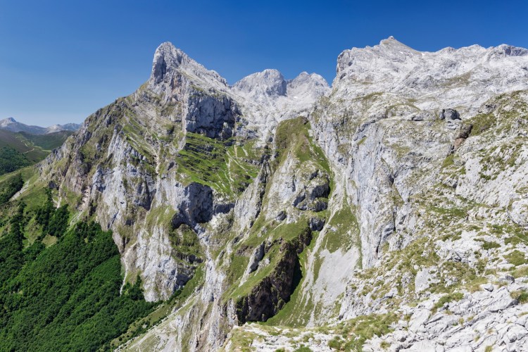
The Cantabrian Mountains (Cordillera Cantábrica) form the rugged mountainous backbone of northern Spain, stretching roughly east to west between the Atlantic-facing coast and the high interior plateau of the Iberian Peninsula. Famous for their lush forests, deep valleys, limestone cliffs, wildlife, and dramatic alpine scenery, they include the spectacular Picos de Europa, one of Spain’s best-known mountain landscapes.
Although the Cantabrian Mountains are lower than the nearby Pyrenees, their proximity to the sea gives them extraordinary relief. In places, steep peaks rise more than 2,000 meters above valleys only a short distance from the Bay of Biscay. The range reaches its highest point at Torre Cerredo, which rises to approximately 2,649 meters (8,691 feet).
🏔️ Overview
Running across northern Spain for roughly 300 kilometers (185 miles), the Cantabrian Mountains form one of the country’s major mountain systems. They extend broadly from the mountains adjoining the Pyrenees and Basque Country in the east toward the uplands of Galicia in the west.
The range crosses or borders several autonomous communities, particularly Asturias, Cantabria, Castile and León, and the Basque Country, while its western mountain landscapes transition into Galicia.
Perhaps the most famous section is the Picos de Europa, a compact collection of extraordinarily rugged limestone massifs. Here, cliffs, karst depressions, narrow gorges, and high summits create scenery that can appear more alpine than the range’s relatively modest elevations might suggest.
The Cantabrian Mountains also form an important climatic barrier. Moist air arriving from the Atlantic Ocean produces abundant precipitation on the northern slopes, helping create the green forests and pastures associated with northern Spain. South of the crest, conditions become progressively drier toward the Meseta Central.
⚡ Fast Facts
| Fact | Details |
|---|---|
| Continent | Europe |
| Country | Spain |
| Regions | Asturias, Cantabria, Castile and León, Basque Country |
| Mountain System | Cantabrian Mountains / Cordillera Cantábrica |
| Highest Peak | Torre Cerredo |
| Highest Elevation | Approximately 2,649 m / 8,691 ft |
| Approximate Length | 300+ km / 185+ mi |
| Orientation | Primarily east–west |
| Major Subrange | Picos de Europa |
| Dominant Rock in Picos de Europa | Limestone |
| Major Protected Area | Picos de Europa National Park |
| Country High Point? | No — Spain’s highest mountain is Teide; mainland Spain’s highest is Mulhacén |
| Notable Wildlife | Cantabrian brown bear, Iberian wolf, Cantabrian chamois |
| Best Known For | Limestone peaks, Atlantic forests, karst scenery, biodiversity and hiking |
📍 Location
The Cantabrian Mountains run roughly parallel to Spain’s northern coastline, separating the narrow Atlantic coastal region from the much broader plateau of Castile and León to the south.
Their location has had a major influence on the geography of northern Spain. Rivers flowing toward the Cantabrian Sea generally descend rapidly through short, steep valleys, while waterways draining southward eventually connect with some of the great river systems of the Iberian interior.
The mountains are especially prominent in Asturias and Cantabria, where steep slopes often rise dramatically behind coastal settlements.
To the east, the range transitions toward the Basque Mountains and the western end of the Pyrenees. To the west, the terrain gradually merges with the mountain systems of Galicia and northwestern Spain.

📏 Elevation & Highest Peak
The highest point in the Cantabrian Mountains is Torre Cerredo, also called Torre de Cerredo or Torrecerredo.
Located in the Central Massif of the Picos de Europa on the boundary between Asturias and León, Torre Cerredo reaches approximately 2,649 meters (8,691 feet).
Several neighboring summits exceed 2,500 meters, making the central Picos de Europa the loftiest and most alpine part of the entire range.
Other prominent mountains of the wider Cantabrian system include Peña Vieja, Peña Prieta, Peña Ubiña, Espigüete, and numerous summits of the Picos de Europa.
What makes these mountains especially dramatic is not simply elevation but vertical relief. Deep gorges and valleys lie far below limestone summits, producing enormous cliffs and steep mountain walls.
🪨 Geology
The geology of the Cantabrian Mountains is unusually complex because the region records more than one major episode of mountain building.
Much of the underlying geological structure originated during the Variscan orogeny hundreds of millions of years ago, when continental collisions deformed rocks across what is now western Europe.
Later tectonic compression associated with the convergence of the Iberian and Eurasian plates during the Alpine mountain-building cycle uplifted and reactivated older structures. This Cenozoic deformation helped create the modern Cantabrian mountain landscape.
The Picos de Europa are particularly famous for thick sequences of Carboniferous limestone.
Water dissolving this limestone over immense periods has produced extensive karst landscapes, including:
- Sinkholes and depressions
- Caves and underground drainage systems
- Sharp limestone ridges
- Vertical shafts
- Rocky pavements
- Narrow gorges
Glacial erosion during the Quaternary further transformed the higher mountains, carving cirques, valleys, and other landforms that contribute to their distinctly alpine appearance.
🌿 Flora & Fauna
The Cantabrian Mountains are one of the great biodiversity refuges of western Europe.
Heavy Atlantic precipitation supports extensive forests on many northern slopes. Depending on elevation, exposure, and location, these may include beech, oak, birch, chestnut, and other deciduous woodland, along with heathlands, scrub, pasture, and alpine vegetation.
Higher elevations support mountain grasslands and specialized plants capable of surviving cold temperatures, strong winds, thin soils, and long periods of snow cover.
The mountains are particularly important for large mammals.
One of their most celebrated inhabitants is the Cantabrian brown bear, a geographically isolated population of European brown bears that survived centuries of habitat loss and persecution. Conservation measures have helped the population recover from extremely low numbers during the late 20th century.
The Cantabrian Mountains are also habitat for the Iberian wolf, red deer, roe deer, wild boar, and the agile Cantabrian chamois.
Birdlife includes golden eagles, vultures, woodland birds, and several species associated with remote highland habitats.
The Picos de Europa alone contain an exceptional concentration of plant diversity, including numerous endemic species.
🥾 Hiking & Climbing Routes
The Cantabrian Mountains offer everything from gentle woodland walks to exposed limestone mountaineering.
The Picos de Europa are the principal destination for high-mountain hiking and climbing. Trails pass through spectacular valleys, beneath limestone towers, and across high mountain terrain where rapidly changing weather can make even moderate routes demanding.
One of the region’s best-known hikes is the Ruta del Cares, which follows the spectacular Cares Gorge through the Picos de Europa. The trail is famous for paths cut directly into steep rock walls above the river.
The Covadonga area provides access to gentler walks among lakes, meadows, and mountain viewpoints, while the Fuente Dé cable car allows visitors to reach high elevations quickly and connect with more demanding mountain trails.
Climbers are particularly drawn to peaks such as Picu Urriellu (Naranjo de Bulnes) and Torre Cerredo.
Torre Cerredo itself is a serious mountaineering objective. Although its normal route is not among Europe’s most technically difficult climbs, exposed scrambling and complex mountain terrain mean it should not be treated as an ordinary hiking summit.
🏔️ Field Guide Tip: Weather in the Cantabrian Mountains can change remarkably quickly because of the range’s proximity to the Atlantic. Carry waterproof layers and navigation equipment even when the forecast appears favorable, particularly when heading into the limestone high country of the Picos de Europa.

🌤️ Best Time to Visit
For most hikers, June through September provides the easiest access to the higher elevations.
Late Spring
May and June bring lush vegetation, flowing streams, and wildflowers, although snow may linger on higher routes. Weather can still be wet and unsettled.
Summer
July and August generally provide the longest daylight hours and easiest access to high trails. These are also among the busiest months in popular parts of the Picos de Europa.
Even during summer, mist, rain, thunderstorms, and sudden temperature changes are possible.
Autumn
September and October can be beautiful, particularly in forested regions where deciduous trees change color. Trails are often quieter, but daylight decreases and increasingly unsettled weather becomes more likely.
Winter
Winter brings snow to the high mountains and transforms the Picos de Europa into serious alpine terrain. Winter hiking and climbing require appropriate equipment, experience, and careful assessment of conditions.
🧭 Nearby Mountains & Attractions
The most important mountain destination within the range is Picos de Europa National Park, which spans Asturias, Cantabria, and Castile and León. Its limestone massifs, deep valleys, traditional villages, wildlife, and extensive trail network make it one of Spain’s outstanding protected mountain landscapes.
Farther west, Somiedo Natural Park preserves another side of the Cantabrian Mountains, with glacial lakes, high pastures, forests, traditional mountain settlements, and important brown bear habitat.
Together, these protected landscapes show the remarkable diversity of the range—from sheer limestone towers to rolling green uplands and deeply forested valleys.
💡 Fun Facts
- The Cantabrian Mountains are surprisingly close to the sea. Some of their steepest mountain scenery lies only a few dozen kilometers from Spain’s northern coastline.
- They help create “Green Spain.” Moist Atlantic air rises over the mountains, producing significantly wetter conditions along the northern side of the range.
- The Picos de Europa are only one part of the Cantabrian Mountains. They are the range’s most famous and highest section, but the broader system extends hundreds of kilometers.
- Spain’s first national park was established here. The original protected area centered on the Covadonga region of the Picos de Europa and later developed into today’s much larger Picos de Europa National Park.
- Brown bears still roam these mountains. The Cantabrian Mountains contain one of western Europe’s most important surviving brown bear populations.
- The range is a major watershed. Streams on the northern slopes descend quickly toward the Cantabrian Sea, while waters draining south enter river systems crossing Spain’s interior.

❓ FAQ
What is the highest mountain in the Cantabrian Mountains?
Torre Cerredo is the highest peak, reaching approximately 2,649 meters (8,691 feet). It lies in the Picos de Europa between Asturias and León.
Where are the Cantabrian Mountains?
They stretch across northern Spain, running roughly parallel to the Bay of Biscay and separating the humid northern coastal regions from the interior plateau of Castile and León.
Are the Picos de Europa part of the Cantabrian Mountains?
Yes. The Picos de Europa are a major limestone massif within the Cantabrian Mountains and contain the range’s highest peaks.
How high are the Cantabrian Mountains?
The highest summit reaches about 2,649 meters, while many major peaks rise above 2,000 meters.
Are there brown bears in the Cantabrian Mountains?
Yes. The mountains support the Cantabrian brown bear population, which has become an important focus of conservation efforts in northern Spain.
Can you hike in the Cantabrian Mountains?
Yes. The region contains an enormous variety of hiking opportunities, from woodland and valley trails to demanding high-mountain routes in the Picos de Europa.
Are the Cantabrian Mountains connected to the Pyrenees?
The two systems are geographically close and form part of the mountainous northern margin of the Iberian Peninsula. The eastern Cantabrian ranges transition through the Basque mountain country toward the western Pyrenees, although the Cantabrian Mountains are generally treated as a distinct mountain system.
🔗 Related Articles
📚 Sources
- Picos de Europa National Park – Official Website
- Spain.info – Picos de Europa National Park
- Turismo Asturias – Ascent of Torrecerredo
- Fundación Oso Pardo – The Number of Bears and Where They Live
- Picos de Europa National Park – Flora
- Picos de Europa National Park – Fauna
- López-Gómez et al. – New Lithostratigraphy for the Cantabrian Mountains
- Seillé et al. – The Crustal Structure of the Cantabrian Mountains
- Peakbagger – Torrecerredo




