The Federated States of Micronesia is an island nation spread across a vast area of the western Pacific Ocean. Although many of its islands are low coral atolls, several are rugged volcanic islands with steep ridges, rainforest-covered summits, waterfalls, and deeply eroded valleys.
The country’s most mountainous landscapes are found on Pohnpei, Kosrae, and the high islands of Chuuk. Pohnpei contains the nation’s highest summit, Mount Nanlaud, as well as nearly all of its highest individual peaks. These mountains are not especially tall by global standards, but their dense vegetation, heavy rainfall, muddy trails, and isolated interiors can make them surprisingly difficult to explore.
🏔️ Overview
The Federated States of Micronesia consists of four states—Yap, Chuuk, Pohnpei, and Kosrae—distributed across the Caroline Islands. Each state contains a mixture of main islands, smaller offshore islands, and coral atolls.
The country’s mountainous islands were shaped by volcanic activity, erosion, tropical rainfall, and the growth of coral reefs around their coastlines. On islands such as Pohnpei and Kosrae, steep volcanic interiors rise directly above coastal plains, mangrove forests, and lagoons.
Visitors exploring the country’s mountains encounter humid rainforest rather than alpine terrain. Summit areas are often covered by cloud forest, moss, ferns, orchids, and dense undergrowth. Similar volcanic landscapes can be found elsewhere in Oceania, although Micronesia’s peaks are distinguished by their tropical climate and isolated island setting.
⚡ Fast Facts
| Fact | Details |
|---|---|
| Continent | Oceania |
| Country | Federated States of Micronesia |
| Pacific region | Micronesia |
| States | Yap, Chuuk, Pohnpei, and Kosrae |
| Highest mountain | Mount Nanlaud, also written Nahnalaud or Nanalaud |
| Highest elevation | Approximately 782 meters (2,566 feet) |
| Highest-mountain location | Pohnpei |
| Other major high points | Ngihneni, Dolohmwar, Mount Finkol, and Winipot |
| Dominant mountain type | Eroded volcanic island mountains |
| Main rock types | Basaltic volcanic rocks, with older metamorphic and volcanic formations on Yap |
| Typical vegetation | Tropical rainforest, montane forest, and cloud forest |
| Main hiking challenges | Rain, mud, steep slopes, river crossings, dense vegetation, and limited marked trails |
📍 Where Are the Mountains Located?
Pohnpei
Pohnpei is the most mountainous state in the country. Its main island is the eroded remnant of a large volcanic system, with a complex network of ridges surrounding valleys, rivers, and waterfalls.
The central highlands contain Mount Nanlaud, Ngihneni, Dolohmwar, Dolmweir, and numerous lesser summits. The mountains help divide the island’s traditional municipalities and create some of the wettest environments in the Pacific.
Pohnpei’s mountains are densely forested, and roads generally remain near the coast. Reaching the central interior often requires hiking along river valleys, hunting trails, farm paths, and narrow ridges.
Kosrae
Kosrae is a compact, steep-sided volcanic island in the eastern part of the country. Its mountainous interior is dominated by Mount Finkol, Finol Mutunte, Mount Buache, and several other forested summits.
The island’s terrain rises abruptly from a narrow coastal zone. Deep valleys, waterfalls, mangrove forests, and cloud-covered peaks make Kosrae one of the most dramatic mountain environments in Micronesia.
Chuuk
Chuuk State includes numerous volcanic islands enclosed within Chuuk Lagoon, together with many outer atolls. The highest point in the state is Winipot, located on Tol, the largest island in the Faichuk group.
Other notable mountains include Winifouror, Tonomwan, Mount Teroken, and Tonnachau Mountain. Although lower than the mountains of Pohnpei and Kosrae, Chuuk’s peaks often have steep slopes and considerable prominence above the surrounding lagoon.
Yap
Yap’s main islands are lower and more gently rolling than Pohnpei or Kosrae. The highest ground reaches approximately 178 meters, but the landscape still includes wooded hills, ridges, traditional stone paths, and viewpoints over mangroves and coastal waters.
Yap is geologically unusual within the country because parts of the main island group contain old metamorphic rocks as well as volcanic formations. Most of Yap State’s outer islands are low coral islands with little or no mountainous terrain.
📏 Highest Mountains in the Federated States of Micronesia
Most of the country’s ten highest mapped summits are clustered in the central highlands of Pohnpei.
| Rank | Mountain | Elevation | Island or Range |
|---|---|---|---|
| 1 | Mount Nanlaud | 782 m (2,566 ft) | Pohnpei Central Highlands |
| 2 | Dolente | 775 m (2,543 ft) | Pohnpei Central Highlands |
| 3 | Mwhaiau | 768 m (2,520 ft) | Pohnpei Central Highlands |
| 4 | Ngihneni | 767 m (2,516 ft) | Pohnpei Central Highlands |
| 5 | Aipakapw | 761 m (2,497 ft) | Pohnpei Central Highlands |
| 6 | Dolohmwar | 761 m (2,497 ft) | Pohnpei Central Highlands |
| 7 | Dolmweir | 734 m (2,408 ft) | Pohnpei Central Highlands |
| 8 | Dolen Kiepw | 732 m (2,402 ft) | Pohnpei Central Highlands |
| 9 | Dole Mweir | 703 m (2,306 ft) | Pohnpei Central Highlands |
| 10 | Dolen Welik | 701 m (2,300 ft) | Pohnpei Central Highlands |
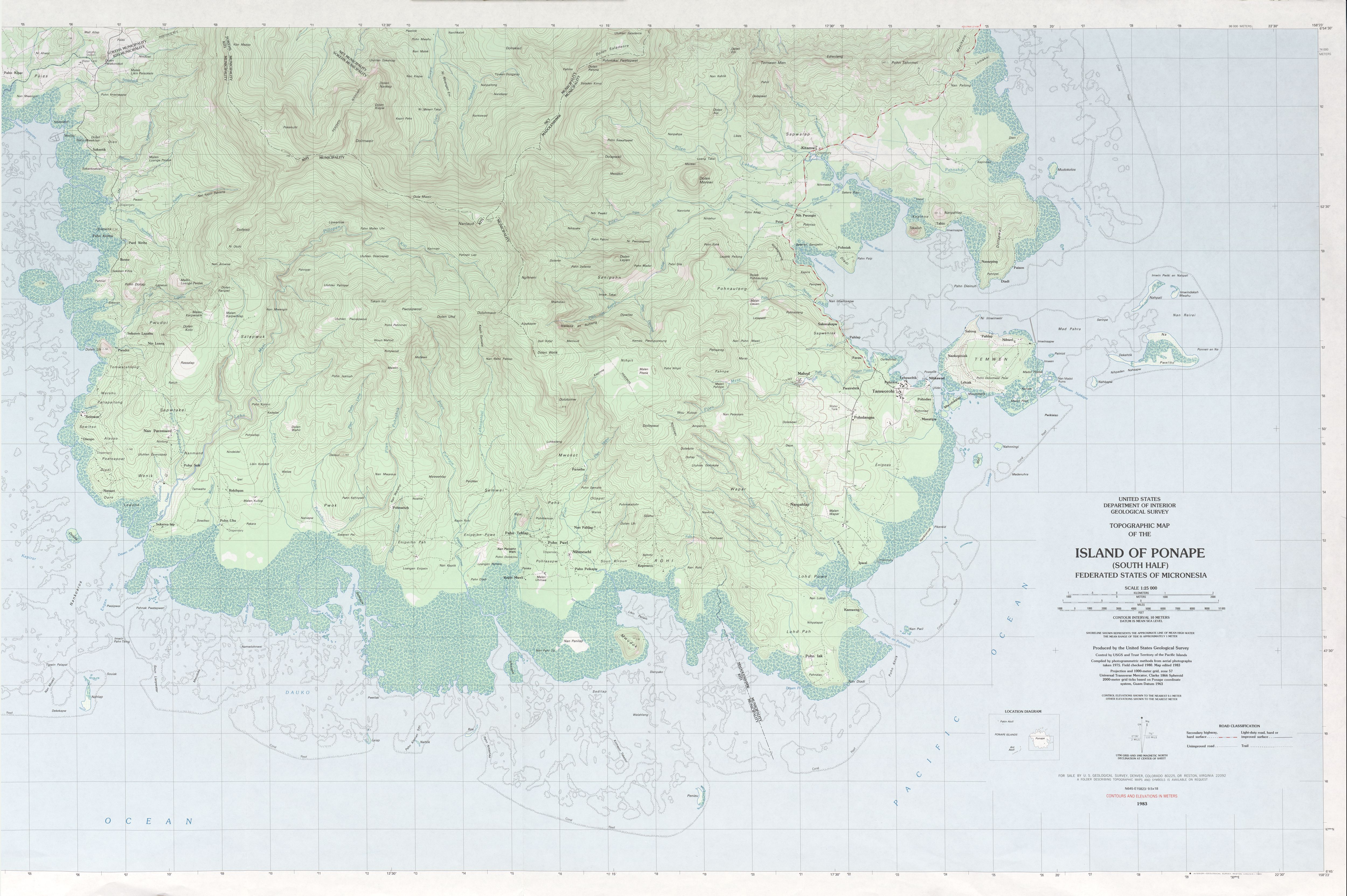
Elevation figures and rankings vary among topographic maps and digital elevation databases. The USGS topographic survey shows Mount Nanlaud reaching the 780-meter contour and gives an elevation of approximately 782 meters. Ngihneni appears to be nearly as high, while Dolohmwar is generally mapped at about 760 meters.
Some databases use computer-generated terrain models that produce slightly different figures and may rank lesser-known subsidiary summits above traditionally recognized mountains.
🏔️ Mount Nanlaud
Mount Nanlaud—also spelled Nahnalaud, Nanalaud, or Nahna Laud—is the highest mountain in the Federated States of Micronesia. It rises in Pohnpei’s remote interior near the boundaries of the Kitti, Nett, and Madolenihmw areas.
The mountain is part of a larger central ridge system rather than an isolated cone. Nearby Ngihneni is nearly the same height, while Dolohmwar stands farther south along the mountainous spine.
Nanlaud receives extraordinary amounts of rainfall. Its upper slopes support a misty cloud-forest environment filled with moss-covered trees, ferns, epiphytes, and waterlogged ground. Clear summit views are uncommon because clouds and fog frequently cover the highlands.
Despite its modest elevation, Nanlaud is a serious wilderness hike. Approaches may involve steep slopes, rivers, mud, slippery rocks, dense vegetation, and long sections without a maintained trail.
⛰️ Other Notable Mountains
Ngihneni
Ngihneni is situated southeast of Mount Nanlaud and is almost equal in elevation. The name is sometimes translated as “spirit’s tooth,” reflecting the mountain’s pointed form and cultural associations.
Because the difference between Nanlaud and Ngihneni is small, older or lower-resolution measurements have created uncertainty about their exact relative heights. The detailed USGS map nevertheless identifies Nanlaud as the recognized national high point.
Dolohmwar
Dolohmwar, also known as Totolom, rises to approximately 760 meters. It is one of Pohnpei’s best-known high summits and forms part of the same rugged interior mountain system as Nanlaud and Ngihneni.
Some geographical databases have incorrectly listed Dolohmwar as the country’s highest mountain, but detailed topographic mapping places it below both Nanlaud and Ngihneni.
Mount Finkol
Mount Finkol is the highest mountain on Kosrae. Published elevations range from approximately 619 to 633 meters, partly because different maps and digital terrain models use different summit locations.
Finkol is surrounded by dense rainforest and is known for its misty upper slopes. The hike is long, steep, and physically demanding, and visitors generally arrange a local guide.
Winipot
Winipot rises to approximately 447–448 meters on Tol Island and is the highest mountain in Chuuk State. Its summit forest provides habitat for the great Truk white-eye, a bird found only in a very limited part of Chuuk.
The mountain’s elevation is much lower than Pohnpei’s highest peaks, but its position on an island within Chuuk Lagoon gives it substantial visual prominence.
Sokehs Ridge and Paipalap
Sokehs Ridge lies northwest of Pohnpei’s main island and is one of the country’s most recognizable mountain landmarks. Its steep basalt cliffs and rock towers rise above the lagoon near Kolonia.
Paipalap, commonly called Sokehs Rock, can be reached by a challenging hike involving steep jungle paths and exposed sections. The ridge offers some of Pohnpei’s best-known panoramic views.
🪨 Geology and Formation
The mountainous islands of the Federated States of Micronesia were created by volcanic processes in the western Pacific. Repeated eruptions built large submarine volcanoes upward from the ocean floor until some emerged as islands.
Pohnpei developed primarily as a shield volcano. Its initial constructional phase occurred millions of years ago, followed by later volcanic activity. Long periods of erosion then carved the original volcanic mass into today’s ridges, valleys, cliffs, waterfalls, and isolated rock formations.
Kosrae and the high islands of Chuuk also have volcanic origins. Kosrae is geologically younger than Pohnpei and retains an especially steep and compact mountainous form.
Rainfall plays a major role in shaping these islands. Rivers cut deeply into weathered lava, while landslides and debris flows modify steep slopes. Pohnpei remains particularly susceptible to slope failures because of its heavy rain, rugged topography, and deeply weathered volcanic soils.
The surrounding coral reefs developed along the edges of the subsiding volcanic islands. Over long periods, some volcanic islands eroded or sank beneath sea level, leaving rings of coral islands and lagoons. This process helps explain why the country contains both mountainous high islands and extremely low atolls. Learn more in How Are Mountains Formed?.
🌿 Flora and Fauna
The mountains support several types of tropical forest. Lower slopes may contain mixed rainforest and agroforest, while wetter upper elevations support montane forest and cloud forest.
Typical highland vegetation includes:
- Moss-covered trees
- Tree ferns
- Pandanus
- Palms
- Orchids and other epiphytes
- Dense climbing plants
- Native shrubs and grasses
Geographic isolation has allowed many distinctive animals to evolve. The country’s forests support endemic birds such as the Pohnpei lorikeet, Pohnpei kingfisher, Pohnpei fantail, Kosrae fruit dove, Chuuk flycatcher, and great Truk white-eye.
Mountain forests are particularly important because many endemic species have small ranges and cannot easily relocate when habitat is cleared or altered. Invasive plants, introduced animals, severe storms, landslides, and climate change all create additional pressures on these ecosystems.
🥾 Hiking and Climbing
Hiking in the Federated States of Micronesia is usually tropical jungle trekking rather than conventional mountaineering. Technical climbing equipment is not normally required for the main hiking routes, but navigation and trail conditions can be difficult.
Popular mountain experiences include:
- Climbing Mount Nanlaud on Pohnpei
- Hiking Sokehs Ridge and Paipalap
- Exploring Pohnpei’s central waterfalls and ridges
- Climbing Mount Finkol on Kosrae
- Hiking Tonnachau Mountain on Weno
- Exploring the forested slopes of Tol and Winipot
- Walking Yap’s traditional stone paths and wooded ridges
Trails may cross private, family, or traditionally managed land. Visitors should obtain permission and arrange a knowledgeable guide rather than assuming that a visible path is open to the public.
🏔️ Field Guide Tip: Hire a local guide for remote mountain hikes. Trails may be unmarked, river levels can rise quickly, and mobile-phone coverage may be unreliable in the interior.
Hikers should carry drinking water, food, rain protection, insect repellent, sturdy footwear, navigation equipment, and a basic first-aid kit. Clothing and equipment should be protected in waterproof bags.
🌤️ Best Time to Visit
The Federated States of Micronesia has a warm tropical climate throughout the year. Temperatures change relatively little, but rainfall, storms, and trail conditions can vary considerably.
Pohnpei and Kosrae receive heavy rain in every season. Even during relatively drier periods, short but intense downpours are common. Mountain summits may remain cloudy when coastal areas are sunny.
The best time for a mountain hike is generally during a stretch of settled local weather rather than during a fixed national hiking season. Visitors should ask guides about recent rainfall, river levels, landslides, and trail damage before leaving.
Avoid exposed ridges during thunderstorms and postpone river crossings following prolonged rain.
🧭 Nearby Natural and Cultural Attractions
Nan Madol
Nan Madol is a UNESCO World Heritage Site located off Pohnpei’s southeastern coast. The ceremonial complex consists of more than 100 artificial islets built with coral fill and enormous basalt stones.
Its columnar basalt walls demonstrate the importance of volcanic rock not only to Pohnpei’s landscape but also to its cultural history.
Kepirohi Waterfall
Kepirohi Waterfall is one of Pohnpei’s best-known natural attractions. Water descends over a broad wall of dark basalt surrounded by dense tropical vegetation.
Chuuk Lagoon
Chuuk Lagoon is internationally known for diving, but its surrounding volcanic islands also create a dramatic mountain-and-lagoon landscape.
Lelu
The archaeological remains of Lelu on Kosrae contain walls and compounds built with basalt. The site reflects the close relationship between the island’s geology and human history.
Yap’s Stone Paths
Yap is famous for its stone money, traditional villages, and old stone pathways. Many routes pass through forested hills and provide an accessible way to explore the island’s gentler terrain.
💡 Fun Facts
- Nearly all of the country’s highest summits are concentrated on Pohnpei.
- Mount Nanlaud is less than 800 meters high but can be more difficult to reach than many much taller mountains.
- The difference in height between Nanlaud and Ngihneni may be only a few meters.
- Pohnpei’s summit forests are frequently surrounded by cloud and fog.
- Winipot contains important habitat for the rare great Truk white-eye.
- Basalt from Pohnpei’s volcanic landscape was used to construct the monumental walls of Nan Madol.
- Many of the country’s outer islands are coral atolls that rise only a few meters above the ocean.
❓ Frequently Asked Questions
What is the highest mountain in the Federated States of Micronesia?
Mount Nanlaud on Pohnpei is the recognized national high point. The USGS topographic survey places its elevation at approximately 782 meters, or 2,566 feet.
Where are most of the country’s mountains?
The largest and highest mountains are on Pohnpei. Kosrae and the volcanic islands of Chuuk also contain substantial mountain terrain, while Yap is generally lower.
Are there mountain ranges in Micronesia?
The country does not have large continental ranges comparable to the Andes or Himalayas. Instead, each high island contains its own ridge systems, peaks, and eroded volcanic massifs.
Are the mountains active volcanoes?
The mountainous islands are the remnants of ancient volcanic systems. They are heavily eroded and are not currently known for active eruptions.
Can visitors climb Mount Nanlaud?
Yes, but it is a demanding wilderness expedition. A local guide is strongly recommended because routes are steep, wet, muddy, and poorly marked.
What is the highest mountain outside Pohnpei?
Mount Finkol on Kosrae is generally regarded as the highest summit outside Pohnpei, reaching approximately 619–633 meters depending on the mapping source.
Are the mountains suitable for beginners?
Shorter hikes such as parts of Sokehs Ridge or established waterfall trails may be suitable for active beginners with a guide. Remote peaks such as Nanlaud and Finkol require greater fitness and preparation.
🔗 Related Articles
- Mountains by Country
- Highest Mountain in Every Country
- Mountains in Fiji
- Mountains in Australia
- How Are Mountains Formed?
- Types of Mountains
📚 Sources
- USGS Topographic Map of the Island of Ponape—South Half
- Mount Nanlaud
- Mountains of Micronesia
- Mountains of Kosrae
- Mountains of Chuuk
- Geology and Hydrogeology of the Island of Pohnpei
- Landslide Susceptibility and Runout Results for Pohnpei
- Nan Madol: Ceremonial Centre of Eastern Micronesia
- Federated States of Micronesia BirdLife Factsheet
- Nahnalaud—The Big Mountain