
Devil’s Peak

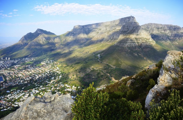
Rising immediately east of Table Mountain above Cape Town, Devil’s Peak is one of the defining summits of South Africa’s famous Cape Peninsula skyline. At approximately 1,001 meters (3,284 feet), the mountain is slightly lower than neighboring Table Mountain but forms an equally important part of the natural amphitheater surrounding Cape Town’s City Bowl.
Seen from Table Bay, Cape Town’s classic mountain skyline runs from Devil’s Peak through Table Mountain to Lion’s Head and Signal Hill. Devil’s Peak is separated from Table Mountain by a high saddle at approximately 704 meters, creating a distinctive twin-mountain profile visible from much of the city.
The mountain is built primarily from extremely resistant quartzitic sandstone of the Table Mountain Group, resting above much older Malmesbury rocks and Cape Granite. These layers preserve more than half a billion years of geological history and explain the contrast between Devil’s Peak’s steep rocky upper slopes and its smoother lower flanks.
Devil’s Peak is equally notable for its biodiversity. It forms part of Table Mountain National Park and the wider Cape Floral Region, one of the richest areas for plant diversity and endemism anywhere on Earth. Rare vegetation includes Peninsula Sandstone Fynbos, Peninsula Shale Fynbos, remnants of critically endangered renosterveld, silver trees, and the extraordinarily localized Devil’s Peak heath.
The mountain also contains layers of human history. The University of Cape Town occupies its lower eastern slopes, while Rhodes Memorial, King’s Blockhouse, old military defenses, forest plantations, and historic trails reflect centuries of change around Cape Town.
Today, Devil’s Peak is a popular hiking mountain offering expansive views across Table Mountain, Cape Town, Table Bay, the Cape Flats, False Bay, and surrounding mountain ranges. Its accessibility should not be mistaken for simplicity: strong winds, rapidly changing weather, fire, steep ravines, navigation problems, and security concerns all require hikers to approach the mountain carefully.
⚡ Fast Facts
| Fact | Details |
|---|---|
| Mountain | Devil’s Peak |
| Afrikaans Name | Duiwelspiek |
| Historic Name | Windberg / Wind Mountain |
| Continent | Africa |
| Country | South Africa |
| Province | Western Cape |
| City | Cape Town |
| Mountain System | Cape Peninsula / Cape Fold Belt |
| Protected Area | Table Mountain National Park |
| Elevation | 1,001 m / 3,284 ft |
| Prominence | 297 m / 974 ft |
| Isolation | 1.38 km / 0.86 mi |
| Key Col | The Saddle, approximately 704 m / 2,310 ft |
| Nearest Higher Neighbor (NHN) | Table Mountain |
| Coordinates | Approximately 33.9544° S, 18.4404° E |
| Highest Rock Type | Peninsula Formation quartzitic sandstone |
| Lower-Slope Rocks | Malmesbury Group, shale and nearby granite |
| Volcano? | No |
| First Ascent | Unknown |
| Principal Vegetation | Fynbos, renosterveld and pockets of Afromontane forest |
| UNESCO Association | Cape Floral Region Protected Areas |
| Notable Landmark | King’s Blockhouse |
| Common Access | The Saddle, Newlands side and Mowbray Ridge routes |
📍 Where Is Devil’s Peak?
Devil’s Peak rises immediately above Cape Town in South Africa’s Western Cape Province.
The mountain forms the easternmost major peak in the famous group surrounding central Cape Town.
From west to east, the best-known landmarks include:
- Signal Hill
- Lion’s Head
- Table Mountain
- Devil’s Peak
Cape Town’s City Bowl lies between these mountains and Table Bay.
The eastern side of Devil’s Peak descends toward suburbs including Rondebosch, Observatory, Mowbray and Newlands, while its northern slopes rise above Woodstock, University Estate and Vredehoek.
The University of Cape Town’s Groote Schuur campus occupies part of the mountain’s lower eastern slope.
This extraordinary location places a major urban university directly beneath one of South Africa’s most important protected mountain landscapes.
🏔️ Devil’s Peak and Table Mountain
Devil’s Peak is closely connected with Table Mountain.
Table Mountain reaches approximately 1,085 meters at Maclear’s Beacon, making it about 84 meters higher than Devil’s Peak.
The two mountains are separated by a broad high saddle known simply as The Saddle.
Peakbagger places Devil’s Peak’s key col at approximately:
704 meters / 2,310 feet
This saddle is important both topographically and for hikers.
Several routes climb toward it before turning east onto Devil’s Peak or west toward Table Mountain.
From Cape Town, the saddle creates the obvious notch between the flat Table Mountain plateau and Devil’s Peak’s more pointed summit.
📏 How High Is Devil’s Peak?
Peakbagger gives Devil’s Peak an elevation of:
1,001 meters / 3,284 feet
Older maps and publications sometimes use approximately 1,000 meters or slightly different figures.
Historical Cape Town sources frequently described it as roughly 3,300 feet high.
Modern topographic mapping places the summit just above the 1,000-meter mark.
That makes Devil’s Peak one of the higher major summits of the northern Cape Peninsula, though still lower than nearby Table Mountain.

📐 Topographic Prominence
Devil’s Peak has approximately:
297 meters / 974 feet
of topographic prominence.
Prominence measures how far a summit rises above the highest saddle connecting it with higher terrain.
In this case, that higher terrain lies on nearby Table Mountain.
Devil’s Peak therefore has modest prominence compared with Table Mountain, whose much greater independent rise gives it over 1,000 meters of prominence.
This does not make Devil’s Peak visually insignificant.
Its steep sides and immediate rise above Cape Town give it a far more imposing appearance than the prominence number might suggest.
🧭 Nearest Higher Neighbor: Table Mountain
Devil’s Peak’s Nearest Higher Neighbor (NHN) is Table Mountain.
Peakbagger gives an isolation of only:
1.38 kilometers / 0.86 miles
That means higher terrain on Table Mountain lies less than a mile away.
This short isolation reflects how closely the two summits are connected geologically and topographically.
They belong to the same great sandstone massif but erosion has separated them into distinct high points.
🪨 Geology of Devil’s Peak
Devil’s Peak provides an excellent introduction to the geology of the Cape Peninsula.
South African National Parks identifies three major rock groups beneath the Table Mountain landscape:
- Malmesbury Group
- Cape Granite
- Table Mountain Group
Each represents a different chapter in the geological history of southwestern Africa.
Devil’s Peak exposes several of these layers particularly clearly.
🪨 The Malmesbury Group
Some of the oldest rocks visible on the lower slopes belong to the Malmesbury Group.
SANParks dates these rocks to approximately 540 million years ago.
They consist largely of:
- Mudstone
- Shale
- Sandstone
- Metamorphosed sedimentary material
These rocks once formed sediments deposited in an ancient marine environment.
Later tectonic deformation folded, heated and altered them.
Because Malmesbury rocks generally weather more readily than the resistant sandstone above, they tend to produce the smoother lower slopes around Devil’s Peak.
🪨 Cape Granite
Around the same broad period, magma intruded into older rocks beneath the Cape Peninsula.
This material cooled underground to create Cape Granite.
Typical minerals include:
- Feldspar
- Quartz
- Mica
Granite forms much of the geological foundation beneath the Table Mountain chain.
It is exposed prominently in several parts of the peninsula, although Devil’s Peak’s upper profile is dominated much more strongly by sandstone.
The interaction between granite and older Malmesbury rocks can be observed at several classic geological localities around Cape Town.
🪨 The Table Mountain Group
Above these ancient basement rocks lie the sedimentary rocks of the Table Mountain Group.
SANParks dates this sequence to roughly 520 million years ago.
The group contains several formations, including:
- Graafwater Formation
- Peninsula Formation
- Pakhuis Formation
The massive pale sandstone cliffs that dominate Devil’s Peak and Table Mountain belong largely to the Peninsula Formation.
This sandstone is exceptionally resistant to erosion.
That resistance explains why the highest mountains of the Cape Peninsula remain standing while softer surrounding rocks have been worn down.
🏔️ Peninsula Formation Sandstone
The upper portion of Devil’s Peak consists mainly of extremely hard quartz-rich sandstone.
It is often informally called Table Mountain sandstone, although modern geological classification uses more specific formation names.
The Peninsula Formation may reach hundreds of meters in thickness.
Its rock is:
- Hard
- Quartz-rich
- Resistant to chemical weathering
- Strongly jointed
Water and weather exploit fractures in the sandstone.
Over millions of years, erosion has created cliffs, buttresses, ravines, ledges and isolated blocks.
These features give Devil’s Peak its rugged upper profile.

🌊 An Ancient Landscape
The sandstone now standing more than 1,000 meters above Cape Town began as sediment in a very different environment.
Sand was transported by ancient rivers and deposited across broad plains and shallow environments.
Over time, the sediment became buried and cemented into sandstone.
Later tectonic forces affected the Cape region.
The rocks were uplifted and ultimately exposed to hundreds of millions of years of erosion.
The mountain visible today is therefore not a recently constructed peak.
It is a resistant remnant of an enormously old landscape.
🌋 Is Devil’s Peak a Volcano?
No.
Devil’s Peak is not volcanic.
Its dramatic name and pointed profile occasionally lead to confusion, but the mountain is made predominantly of ancient sedimentary and metamorphic rocks rather than volcanic lava.
The upper mountain consists largely of sandstone.
Its form developed through:
- Tectonic uplift
- Weathering
- River erosion
- Rockfall
- Differential erosion
No volcanic crater or volcanic cone is involved.
⛰️ Why Is Devil’s Peak Pointed While Table Mountain Is Flat?
Devil’s Peak and Table Mountain contain much of the same resistant sandstone, yet their forms are noticeably different.
Table Mountain retains a broad plateau.
Devil’s Peak narrows toward a more conventional summit.
The difference results from prolonged erosion.
Fractures, drainage channels and ravines have progressively isolated and narrowed Devil’s Peak.
Table Mountain retained a larger surviving block of resistant sandstone.
Signal Hill illustrates the process even more dramatically.
Much of its sandstone cap has been stripped away, leaving a lower and more rounded ridge.
Together, the peaks provide a striking visual demonstration of differential erosion.
🌬️ The Wind Mountain
Before the Devil’s Peak name became dominant, the mountain was historically known as Windberg, meaning approximately Wind Mountain.
The name was appropriate.
Cape Town is famous for strong southeasterly winds, particularly during the warmer months.
These winds interact with Table Mountain and Devil’s Peak, accelerating through gaps and down slopes.
Devil’s Peak can therefore experience much stronger conditions than lower areas of Cape Town.
Wind remains one of the principal hazards for hikers near the summit.
☁️ The Tablecloth Cloud
Cape Town’s famous tablecloth cloud forms when moist air is forced upward across the mountains.
As air rises, it cools.
Moisture condenses and forms cloud.
The cloud may spill dramatically across Table Mountain and neighboring Devil’s Peak before dissipating as air descends on the other side.
The phenomenon is striking from the city.
When Devil’s Peak is hidden in rapidly moving cloud while Table Mountain disappears beneath a white blanket, conditions on the summit can be far colder, wetter and windier than they appear from below.
😈 Why Is It Called Devil’s Peak?
The exact naming history is less certain than many popular stories suggest.
Historical sources indicate that names such as Windberg and Charles Mountain were used before Devil’s Peak became established.
The English name developed from Dutch or Afrikaans forms associated with “Devil’s Head” or “Devil’s Peak.”
Today, however, the most famous explanation comes from the legend of Jan van Hunks.
🚬 Jan van Hunks and the Devil
According to Cape Town folklore, Jan van Hunks was an exceptionally enthusiastic pipe smoker.
One day, while smoking on the mountain slopes, he encountered a mysterious stranger.
The two began arguing about who could smoke more tobacco.
A smoking contest followed.
Clouds of smoke became so enormous that they covered the mountains.
Eventually, Van Hunks defeated his opponent.
The stranger then revealed himself to be the Devil.
In popular retellings, the smoke produced during their contest became the cloud that still spills across Table Mountain.
📖 Legend Versus History
The Jan van Hunks story is entertaining, but it should not be treated as a securely documented explanation for the mountain’s name.
Versions of the story became popular through nineteenth- and early twentieth-century literature.
The tale appears to have developed later than some popular retellings suggest.
It is therefore best understood as Cape Town folklore rather than proven place-name history.
That distinction makes the story no less interesting.
The legend demonstrates how Cape Town residents transformed the mountain’s dramatic wind and cloud into a memorable cultural narrative.
🧑🤝🧑 Indigenous History
Long before European settlement, the Cape Peninsula was home to Indigenous communities including Khoekhoe and San peoples.
The mountains, valleys, springs, wildlife and seasonal landscapes formed part of a much older human geography than the written colonial record.
Unfortunately, surviving colonial place names and documents preserve only a fraction of those earlier relationships with the mountain.
Modern discussions of Devil’s Peak should therefore avoid implying that the history of the landscape began when Europeans established Cape Town in the seventeenth century.
People had lived around and moved through the Cape landscape for thousands of years.
🏘️ Cape Town Grows Beneath the Mountain
The Dutch East India Company established its settlement at the Cape in 1652.
Over time, farms spread toward the slopes beneath Devil’s Peak and Table Mountain.
The Liesbeek River and surrounding fertile land became especially important to early colonial agriculture.
The landscape changed dramatically.
Forests were harvested.
Land was cultivated.
Roads and military defenses appeared.
Later, urban Cape Town expanded progressively higher toward the mountain.
Today, the boundary between national park and city is unusually sharp.
Wild fynbos may occur only a short distance above densely developed urban neighborhoods.
🏰 King’s Blockhouse
One of Devil’s Peak’s most important historic landmarks is King’s Blockhouse.
The British occupied the Cape in 1795.
Recognizing weaknesses in existing defenses, they expanded the military fortification system onto the slopes of Devil’s Peak.
Three important blockhouses were constructed:
- Queen’s Blockhouse
- Prince of Wales Blockhouse
- King’s Blockhouse
King’s Blockhouse occupied the most prominent high position.
Its location provided views across both Table Bay and False Bay approaches.
🧱 A Strategic Lookout
The blockhouse was designed to help defend Cape Town against attack from the landward side.
Its position on Mowbray Ridge offered an exceptional observation point.
It later served as a signal station connecting military positions around the Cape.
The stone building survives and remains one of the mountain’s most recognizable man-made landmarks.
South African History Online notes that it was declared a National Monument in 1938 under earlier heritage legislation.
Modern hikers frequently visit King’s Blockhouse without continuing all the way to Devil’s Peak’s summit.
🎓 University of Cape Town
The University of Cape Town occupies the lower eastern slopes of Devil’s Peak.
Its Groote Schuur campus climbs upward from Rondebosch beneath the mountain.
The location provides remarkable views across the Cape Flats and surrounding ranges.
It also places university buildings directly beside a fire-dependent natural ecosystem.
That relationship became dramatically apparent during the 2021 Table Mountain wildfire.
🔥 The 2021 Devil’s Peak Fire
On April 18, 2021, a major wildfire began near Rhodes Memorial on the slopes of Devil’s Peak.
Strong winds and dry conditions helped spread the fire rapidly.
The blaze affected parts of Table Mountain National Park and the University of Cape Town.
Historic structures and collections were damaged, including portions of UCT’s library complex.
The fire became one of the most widely reported Cape Town wildfires of recent decades.
Yet fire itself is not foreign to Devil’s Peak.
It is a fundamental ecological process within fynbos.
The problem lies in the timing and frequency of fires.
🔥 Fynbos Needs Fire
Fynbos ecosystems evolved with periodic wildfire.
Many species depend on fire to:
- Release seeds
- Stimulate germination
- Remove old vegetation
- Recycle nutrients
- Create open habitat
SANParks notes that many fynbos communities require fire at intervals of roughly a decade or longer.
Too little fire can allow vegetation to become old and senescent.
Too much fire can be equally destructive.
If young plants burn before producing seeds, entire local populations can disappear.
This is particularly serious on Devil’s Peak because several rare plants occur nowhere else.
🌿 Flora and Fauna
Devil’s Peak lies within one of the most botanically extraordinary landscapes in the world.
Table Mountain National Park forms part of the Cape Floral Region Protected Areas UNESCO World Heritage Site.
UNESCO identifies the Cape Floral Region as one of the world’s greatest centers of:
- Plant diversity
- Endemism
- Adaptive radiation
- Specialized pollination
- Fire-driven ecology
The entire Cape Floral Region covers less than 0.5% of Africa yet contains nearly 20% of the continent’s plant flora.
🌿 Peninsula Sandstone Fynbos
The rocky upper slopes of Devil’s Peak support Peninsula Sandstone Fynbos.
The nutrient-poor sandstone soils encourage vegetation adapted to difficult conditions.
Typical fynbos plant groups include:
- Proteas
- Ericas
- Restios
- Geophytes
Rather than forming tall forest, mature fynbos usually creates a dense shrubland.
Many individual species have extremely restricted ranges.
Some occur only on a single mountain or even one section of one slope.
🌱 Peninsula Shale Fynbos
Lower portions of Devil’s Peak occur on richer shale-derived soils.
These areas support Peninsula Shale Fynbos.
Because shale soils are relatively fertile, much of this vegetation type was historically converted for:
- Farms
- Roads
- Housing
- Urban development
The remaining patches are therefore particularly valuable.
Devil’s Peak preserves some of the surviving natural vegetation immediately beside central Cape Town.
🌾 Renosterveld
SANParks identifies renosterveld vegetation on portions of Devil’s Peak, especially where Malmesbury shale occurs.
This ecosystem once covered much larger areas of the Cape lowlands.
Urbanization and agriculture destroyed most of it.
Only a small percentage remains.
Fire plays an important role here as well.
After appropriate burns, bulbs and flowering plants can produce spectacular displays.
Because Devil’s Peak lies directly beside a city, managing natural fire cycles is particularly complicated.
🌺 Devil’s Peak Heath
One of the mountain’s most special plants is Devil’s Peak heath:
Erica abietina subsp. diabolis
The South African National Biodiversity Institute classifies this plant as Critically Endangered.
Its known habitat is extraordinarily small.
SANBI describes its entire population as occurring within an area of less than one square kilometer on Table Mountain and Devil’s Peak.
It grows on rocky upper and summit slopes within Peninsula Sandstone Fynbos.
The greatest threat is fire occurring too frequently.
Because the plant relies on seeds to regenerate after fire, another burn before young plants mature can eliminate entire generations.

🌳 Silver Trees
The lower eastern slopes around Rhodes Memorial contain populations of the famous silver tree, Leucadendron argenteum.
Its silvery leaves reflect sunlight and make mature trees particularly striking.
The species occurs naturally only within a restricted region around the Cape Peninsula.
Urbanization, altered fire regimes, invasive species and historical plantations have reduced and fragmented its habitat.
Devil’s Peak remains one of the important areas where naturally occurring silver trees can still be found.
🌲 Afromontane Forest
The wetter southern and eastern ravines of Devil’s Peak support pockets of Afromontane forest.
These sheltered forests are very different from open fynbos.
Trees can create cool, shady environments within narrow kloofs.
Historically, larger areas of indigenous forest were cut for timber.
Some sites were later replaced by plantations of non-native trees.
Small surviving forest patches provide important habitat and demonstrate how dramatically vegetation can change over only short distances around the mountain.
🌲 Pine Plantations and Restoration
Large areas of the Cape Peninsula were historically planted with non-native pine trees.
Devil’s Peak and nearby Newlands were among the landscapes affected.
Pine plantations changed:
- Fire behavior
- Water use
- Soil conditions
- Native vegetation
- Habitat structure
Modern conservation management has included removing invasive or plantation trees in appropriate areas and restoring indigenous fynbos.
This process is complicated.
Some planted forests have also become culturally familiar recreational landscapes, while ecologically they occupy land that once supported globally rare native vegetation.
🐾 Mammals
Table Mountain National Park supports a surprising variety of mammals despite being surrounded by a major city.
Species recorded within the park include:
- Caracal
- Cape porcupine
- Cape grysbok
- Common duiker
- Klipspringer
- Grey rhebok
- Cape grey mongoose
Not every species should be expected directly on Devil’s Peak itself.
Habitat requirements vary substantially across the peninsula.
Nevertheless, the mountain forms part of a connected protected landscape allowing wildlife to survive remarkably close to urban Cape Town.
🐈 Caracal
The caracal is one of the most impressive predators remaining in the Table Mountain landscape.
These medium-sized wild cats are secretive and primarily active when human activity is lower.
They prey on smaller mammals and birds.
Caracals sometimes move surprisingly close to urban neighborhoods.
Research and monitoring around Cape Town have helped reveal how these predators navigate a landscape fragmented by roads, suburbs and recreational activity.
Hikers rarely see them.
Tracks or camera-trap records are far more common than direct encounters.
🦔 Cape Porcupines
Cape porcupines also occur within Table Mountain National Park.
They are primarily nocturnal.
These large rodents feed on plant material and can dig for roots and underground storage organs.
Their dramatic quills make them unmistakable when encountered.
Like many mammals of the park, porcupines usually remain hidden during the hours when most hikers are on the mountain.
🦌 Small Antelope
Several small antelope species survive within the wider park.
SANParks lists animals such as:
- Klipspringer
- Cape grysbok
- Common duiker
- Grey rhebok
These animals are much smaller than the large antelope associated with South African savannas.
Their size is well suited to fynbos, rocky ridges and broken mountain terrain.
Early morning and evening offer the best chance of seeing some species.
🐦 Birds
Table Mountain National Park has recorded approximately 250 bird species across its varied habitats.
Characteristic fynbos birds include:
- Cape sugarbird
- Orange-breasted sunbird
- Malachite sunbird
- Lesser double-collared sunbird
- Karoo prinia
- Grey-backed cisticola
Many of these birds have close ecological relationships with flowering fynbos plants.
Sunbirds and sugarbirds are particularly important pollinators.
The result is a mountain ecosystem in which plant and bird evolution are closely interconnected.
🦋 Insects and Pollination
Insects also play essential ecological roles.
Many Cape plants rely on highly specialized pollinators.
SANParks highlights the Mountain Pride butterfly as an especially important example.
This butterfly is closely associated with the pollination of red-flowered mountain plants.
Beetles, flies, bees, ants and other insects also act as:
- Pollinators
- Seed dispersers
- Herbivores
- Prey for birds and reptiles
The extraordinary plant richness of the Cape cannot be understood without the insect communities that help maintain it.
🌍 The Cape Floral Region
Devil’s Peak sits within the Cape Floristic Region, one of the six major floral kingdoms traditionally recognized worldwide.
It is the smallest.
Yet relative to its area, it is extraordinarily diverse.
UNESCO reports roughly:
9,000 plant species
within the wider region, with approximately 69% endemic.
That means nearly seven out of ten species occur naturally nowhere else on Earth.
This makes conservation on Devil’s Peak globally significant despite the mountain’s relatively modest elevation.
🏛️ UNESCO World Heritage Status
Table Mountain National Park forms one component of the Cape Floral Region Protected Areas UNESCO World Heritage Site.
The serial World Heritage property was initially inscribed in 2004 and later expanded.
UNESCO recognizes it for extraordinary ecological and evolutionary processes as well as exceptional plant diversity and endemism.
Devil’s Peak therefore lies inside a landscape protected not only because it is beautiful but because its biological value is globally exceptional.
🥾 Hiking Devil’s Peak
Devil’s Peak offers numerous hiking possibilities.
Some routes visit lower landmarks.
Others reach the summit.
The difficulty varies considerably.
A route described casually as a “Devil’s Peak hike” might mean:
- A walk to King’s Blockhouse
- A contour-path excursion
- A climb toward The Saddle
- A full summit ascent
- A steep ravine or scrambling route
Hikers should therefore identify their exact route before leaving.
🥾 The Saddle Route
One of the most straightforward summit approaches reaches The Saddle between Devil’s Peak and Table Mountain.
From the saddle, a clear path continues toward Devil’s Peak’s summit.
The final section is hiking terrain rather than technical climbing under normal dry conditions.
The difficulty comes from the overall elevation gain, sun exposure, wind and rapidly changing weather.
The summit provides one of the best viewpoints toward Table Mountain itself.
🥾 Newlands Ravine
Newlands Ravine provides an important approach from the wetter eastern side.
The route climbs through vegetation toward the saddle between Table Mountain and Devil’s Peak.
Compared with the exposed northern slopes, the Newlands side can feel much greener.
Sections are steep.
After rain, rocks and trail surfaces may be slippery.
Once hikers reach The Saddle, they can continue toward Devil’s Peak.
🥾 Mowbray Ridge
Mowbray Ridge provides another important route through the Devil’s Peak landscape.
The ridge is closely associated with King’s Blockhouse.
Many hikers visit the historic fortification as a destination in its own right.
Continuing higher leads into more demanding mountain terrain.
Mowbray Ridge provides excellent views across:
- Cape Flats
- Table Bay
- False Bay
- University of Cape Town
- Surrounding suburbs
🥾 King’s Blockhouse Walk
For visitors who do not need to reach the summit, King’s Blockhouse makes an excellent objective.
The historic structure can be approached from the Rhodes Memorial and Newlands side of the mountain.
The route combines:
- History
- Fynbos
- City views
- Military heritage
- Mountain scenery
Because the blockhouse sits far below the 1,001-meter summit, it requires less climbing than a full Devil’s Peak ascent.
It is nevertheless a genuine mountain walk.
🥾 Upper Routes and Ravines
Several more difficult routes exist on Devil’s Peak.
These may involve:
- Steep ravines
- Scrambling
- Loose terrain
- Route-finding
- Exposure
Not every visible ravine provides a safe hiking route.
This is important because the mountain’s gullies can look deceptively direct from below.
Some have cliffs or dangerous exits.
Hikers unfamiliar with Cape Town mountains should choose established routes and obtain current local guidance before attempting less-traveled lines.
👀 Views from Devil’s Peak
The summit provides one of the finest perspectives on Table Mountain.
From the top, hikers can look west across The Saddle toward the massive sandstone cliffs and plateau.
Other views may include:
- Cape Town City Bowl
- Table Bay
- Robben Island in clear weather
- Lion’s Head
- Signal Hill
- Cape Flats
- False Bay
- Hottentots Holland Mountains
- Stellenbosch-area mountains
- Southern suburbs
Because Devil’s Peak stands east of Table Mountain, its viewpoint is fundamentally different from those reached by the Table Mountain Cableway.
🌬️ Wind Hazard
Wind is one of the most important hazards on Devil’s Peak.
The mountain’s historical name Windberg is a useful warning.
Strong southeasterly winds can make exposed summit areas difficult or unsafe.
Powerful gusts affect:
- Balance
- Body temperature
- Communication
- Visibility when cloud arrives
- Progress on exposed terrain
A calm morning in the city does not guarantee calm conditions at 1,000 meters.
Hikers should reassess conditions continuously.
🌫️ Cloud and Navigation
Cloud can develop rapidly around Table Mountain and Devil’s Peak.
Once visibility disappears, trails that seemed obvious in clear conditions can become difficult to follow.
The sandstone terrain contains multiple ridges, gullies and branching paths.
Poor visibility also makes it harder to identify dangerous drop-offs.
Hikers should carry reliable navigation and know how to retrace their route rather than depending entirely on distant visual landmarks.
☀️ Heat and Water
Cape Town summers can be hot and dry.
Many northern sections of Devil’s Peak offer limited shade.
Upper slopes may have no dependable drinking water.
Heat combined with sustained climbing can lead to dehydration surprisingly quickly.
Hikers should carry enough water for the full route rather than planning to refill from mountain streams.
Sun protection is equally important.
🔥 Wildfire Risk
Wildfire is a natural feature of the fynbos landscape.
During hot, dry and windy weather, however, fire can spread extremely rapidly.
Hikers may have little time to escape once a fire moves onto a slope.
Visitors should never enter areas closed because of fire danger or active firefighting.
Smoke visible elsewhere on the mountain should be treated seriously.
The 2021 fire showed how rapidly flames can travel between national park land and densely developed portions of Cape Town.
⚠️ Security
Devil’s Peak lies directly beside a large city, creating security issues unusual for many mountain destinations.
Incidents of crime have occurred on trails around the Table Mountain complex.
Hikers should:
- Avoid isolated routes when possible
- Hike with others
- Check current SANParks safety information
- Avoid displaying unnecessary valuables
- Tell someone their intended route
- Return well before dark
- Follow closures and local warnings
Conditions can change, so current official guidance is more useful than relying solely on an older trail description.
📅 Best Time to Hike Devil’s Peak
Devil’s Peak can potentially be hiked throughout the year, but conditions vary dramatically.
Summer
Summer generally brings:
- Dry conditions
- Strong southeasterly wind
- High temperatures
- Significant sun exposure
- Increased wildfire danger
Starting early is usually preferable.
Winter
Winter can bring:
- Cooler temperatures
- Rain
- Cloud
- Wet rock
- Strong frontal weather
Clear winter days can also provide superb hiking conditions.
Spring
Spring is especially attractive for fynbos flowers.
Autumn
Autumn may combine milder temperatures with relatively settled conditions, although severe weather and fire are still possible.
There is no single guaranteed safe season.
The forecast matters more than the calendar.
🧭 No Cableway
Unlike Table Mountain, Devil’s Peak has no cableway.
Anyone reaching the summit must also descend on foot.
This matters when planning time and energy.
Hikers should resist treating the summit as the halfway point only psychologically.
It is literally the halfway point of a return hike unless using a carefully planned alternative route.
Enough daylight, water and energy must remain for the descent.
🏆 First Ascent of Devil’s Peak
There is no reliable documented first ascent of Devil’s Peak.
The mountain lies directly beside an area inhabited for thousands of years.
Indigenous people almost certainly traveled throughout portions of the mountain landscape long before European records began.
Later farmers, soldiers, surveyors, foresters and residents also moved across its slopes.
Unlike Table Mountain, which has a well-known recorded European ascent by António de Saldanha in 1503, Devil’s Peak does not have an equivalent universally accepted first-ascent record.
For a Mountain Field Guide profile, “first ascent unknown” is therefore the most accurate choice.
🌏 Why Devil’s Peak Matters
Devil’s Peak is not one of Africa’s highest mountains.
It does not possess Table Mountain’s enormous prominence.
It has no cableway and no globally famous summit monument.
Yet its significance is exceptional.
The mountain combines:
- Ancient geology
- Dramatic urban relief
- Globally important biodiversity
- Rare endemic plants
- Fire-dependent ecosystems
- Colonial military history
- Indigenous cultural landscapes
- University and city history
- Accessible hiking
- One of the world’s most recognizable mountain skylines
Few mountains of only about 1,000 meters contain so much biological, geological and cultural complexity.
Devil’s Peak succeeds precisely because it is inseparable from its surroundings.
Table Mountain gives it context.
Cape Town gives it human history.
The Cape Floral Region gives it extraordinary biodiversity.
Together, they make Devil’s Peak one of South Africa’s most interesting urban mountains.

💡 Devil’s Peak Fun Facts
- Devil’s Peak reaches approximately 1,001 meters (3,284 feet).
- It rises immediately east of Table Mountain.
- Its topographic prominence is approximately 297 meters.
- Its key col is The Saddle at about 704 meters.
- Its isolation is approximately 1.38 kilometers.
- Its Nearest Higher Neighbor is Table Mountain.
- Devil’s Peak was historically known as Windberg, or Wind Mountain.
- The name accurately reflects the powerful winds experienced around the summit.
- The popular Jan van Hunks smoking story is folklore rather than securely documented naming history.
- The upper mountain consists mainly of ancient quartzitic sandstone.
- Lower slopes expose older Malmesbury rocks.
- Devil’s Peak is not a volcano.
- The mountain forms part of Table Mountain National Park.
- It also lies within the Cape Floral Region UNESCO World Heritage landscape.
- Rare vegetation includes Peninsula Sandstone Fynbos and Peninsula Shale Fynbos.
- Remnants of critically endangered renosterveld occur on lower slopes.
- Devil’s Peak heath is Critically Endangered and has an extremely restricted range.
- Silver trees grow naturally on portions of the eastern slopes.
- Small patches of indigenous Afromontane forest survive in wetter ravines.
- The University of Cape Town lies on the mountain’s eastern slopes.
- Rhodes Memorial is located below the summit.
- King’s Blockhouse dates to the British military occupation of the Cape.
- Three major blockhouses were constructed on Devil’s Peak.
- King’s Blockhouse provided views toward both Table Bay and False Bay.
- A major wildfire affected Devil’s Peak and UCT in April 2021.
- Fire is naturally important to fynbos, but fires occurring too frequently threaten rare plants.
- Table Mountain National Park supports mammals including caracal and Cape porcupine.
- Fynbos birds include Cape sugarbirds and several sunbird species.
- Devil’s Peak has no cableway.
- A full summit visit requires hiking both up and down.
- No reliable historical first ascent has been established.
❓ Devil’s Peak FAQ
How high is Devil’s Peak?
Devil’s Peak reaches approximately 1,001 meters (3,284 feet) above sea level.
Where is Devil’s Peak?
Devil’s Peak is located in Cape Town, Western Cape, South Africa.
It rises immediately east of Table Mountain.
Is Devil’s Peak part of Table Mountain?
Devil’s Peak is a distinct named summit but forms part of the same larger mountain massif and Table Mountain National Park landscape.
The two mountains are separated by The Saddle.
What is Devil’s Peak’s Nearest Higher Neighbor?
The Nearest Higher Neighbor (NHN) is Table Mountain.
How prominent is Devil’s Peak?
Peakbagger gives the mountain approximately 297 meters (974 feet) of topographic prominence.
How isolated is Devil’s Peak?
Its topographic isolation is approximately 1.38 kilometers (0.86 miles).
What is Devil’s Peak made of?
Its upper slopes consist largely of resistant quartzitic sandstone of the Peninsula Formation within the Table Mountain Group.
Older Malmesbury rocks occur lower on the mountain, with Cape Granite forming part of the broader geological basement.
Is Devil’s Peak a volcano?
No.
Devil’s Peak is not volcanic.
Its shape results from erosion of ancient sedimentary and basement rocks.
Why is it called Devil’s Peak?
The precise history is uncertain.
The mountain was historically known as Windberg, while later Dutch/Afrikaans and English names became associated with the Devil.
The famous Jan van Hunks smoking-contest story is a later piece of Cape Town folklore.
What is the Jan van Hunks legend?
The legend tells of a pipe smoker named Jan van Hunks who challenged a stranger to a smoking contest on the mountain.
The stranger was eventually revealed as the Devil, and their smoke supposedly produced the famous clouds over Table Mountain.
It should be treated as folklore rather than established historical fact.
Who first climbed Devil’s Peak?
There is no reliable documented first ascent.
People lived around the Cape Peninsula long before written European records, making a modern-style first-ascent claim inappropriate.
Is Devil’s Peak inside Table Mountain National Park?
Yes.
The mountain forms part of Table Mountain National Park.
Is Devil’s Peak part of a UNESCO World Heritage Site?
Table Mountain National Park is one of the protected areas included within the Cape Floral Region Protected Areas UNESCO World Heritage Site.
What plants grow on Devil’s Peak?
Vegetation includes fynbos, renosterveld, silver trees, ericas, restios, proteas, bulbs and small pockets of Afromontane forest.
What is Devil’s Peak heath?
Erica abietina subsp. diabolis, commonly known as Devil’s Peak heath, is a Critically Endangered plant with an extremely small range centered on the upper Devil’s Peak and Table Mountain landscape.
Why is fire important on Devil’s Peak?
Fynbos evolved with periodic wildfire, and many plants require fire to reproduce successfully.
However, excessively frequent fires can destroy plants before they mature and replenish the seed bank.
What wildlife lives around Devil’s Peak?
The broader Table Mountain National Park supports mammals including caracal, Cape porcupines, small antelope and mongooses, along with many birds, reptiles and insects.
Can you hike to the top of Devil’s Peak?
Yes.
Several routes reach the summit.
One of the more straightforward approaches reaches The Saddle before climbing to the top.
Is Devil’s Peak an easy hike?
That depends on the chosen route.
The standard summit approach is hiking rather than technical climbing, but the mountain involves significant elevation gain, exposed terrain, wind, sun and rapidly changing weather.
Some alternative ravines and ridges are substantially more difficult.
What is The Saddle?
The Saddle is the high col between Devil’s Peak and Table Mountain.
It lies at approximately 704 meters and provides access to both mountains.
Can you take a cable car up Devil’s Peak?
No.
There is no cableway on Devil’s Peak.
Summit visitors must hike.
What is King’s Blockhouse?
King’s Blockhouse is a historic British defensive structure on Mowbray Ridge.
It was built after the British occupied the Cape in 1795 and formed part of a network protecting Cape Town from landward attack.
Is Rhodes Memorial on Devil’s Peak?
Yes.
Rhodes Memorial lies on the mountain’s lower eastern slopes.
Is the University of Cape Town on Devil’s Peak?
UCT’s Groote Schuur campus occupies part of the lower eastern slope of Devil’s Peak in Rondebosch.
When is the best time to hike Devil’s Peak?
Good hiking days can occur throughout the year.
The safest choice depends on current wind, temperature, rain, fire danger, trail status and security conditions rather than a specific month.
🔗 Related Articles
- Table Mountain, South Africa: Hiking Trails, Cableway & Visitor Guide
- The Devilish Origins of South Africa’s Iconic Devil’s Peak
- Mountains in South Africa: Highest Peaks, Major Ranges & Hiking Guide
- Mountain Ranges
📚 Sources
- Peakbagger — Devil’s Peak
- South African National Parks — Table Mountain National Park Geology
- South African National Parks — Table Mountain National Park Vegetation
- South African National Parks — Table Mountain National Park Mammals
- South African National Parks — Table Mountain National Park Birds
- South African National Parks — Table Mountain National Park Insects
- South African National Parks — King’s Blockhouse
- South African National Parks — Rhodes Memorial
- UNESCO World Heritage Centre — Cape Floral Region Protected Areas
- SANBI Red List — Devil’s Peak Heath
- SANBI Red List — Silver Tree
- South African History Online — King’s Blockhouse, Devil’s Peak
- University of Cape Town — Directions and Campus Location




2 comments
Where does the ‘Devil’s’ peak come from?
Hello! It got its name from a folktale about a Dutchman and the devil competing in a smoking contest on the slopes of the peak: https://en.wikipedia.org/wiki/Devil%27s_Peak_(Cape_Town).