
Namcha Barwa (Namchabarwa, གནམས་ལྕགས་འབར་བ།, Namjagbarwa, 南迦巴瓦峰, Nánjiābāwǎ Fēng)

Namcha Barwa is one of the most distinctive and geographically important mountains in the Himalayas. Rising to 7,782 meters (25,531 feet) in southeastern Tibet, it stands beside the immense bend of the Yarlung Tsangpo River, where the river turns south and cuts through the eastern end of the Himalayan system. By the traditional geographic definition of the range, Namcha Barwa forms the Himalayas’ eastern anchor, just as Nanga Parbat marks their western end.
Although it is not one of the fourteen 8,000-meter peaks, Namcha Barwa is exceptional in nearly every other measure. It is the 27th-highest mountain in the world, has more than 4,100 meters of topographic prominence, and rises with extraordinary abruptness above deep, forested river valleys. The mountain’s great height, sharply pointed summit, frequent cloud cover, and tremendous vertical relief give it a visual presence out of proportion even to its Himalayan elevation.
Namcha Barwa also occupies one of the most geologically active sections of the entire mountain chain. Here, the structures of the Himalayas bend sharply around the northeastern corner of the Indian Plate, creating the complex region known as the eastern Himalayan syntaxis. Deeply buried metamorphic rocks have been uplifted and exposed at unusually rapid rates, while the Yarlung Tsangpo and its tributaries transport enormous quantities of eroded material toward the Brahmaputra basin.
The mountain remained unclimbed until October 30, 1992, when members of a joint Chinese-Japanese expedition reached its summit. Until that ascent, Namcha Barwa had been regarded as the highest unclimbed independent mountain on Earth. Its remoteness, severe weather, avalanche-prone ridges, and steep mixed terrain have ensured that it remains far less frequently climbed than most other major Himalayan peaks.
🏔️ Overview
Namcha Barwa stands in the historic region of Pemako, a remote area of southeastern Tibet associated with deep valleys, subtropical forests, high mountain ridges, and Tibetan Buddhist traditions concerning hidden lands or beyul. The mountain rises near the inside of the Great Bend of the Yarlung Tsangpo, where the river curves around the Namcha Barwa–Gyala Peri massif before continuing toward India.
The peak is the highest summit of the Namcha Barwa Himal, a roughly 180-kilometer mountain section occupying the easternmost part of the conventional Himalayan arc. It is also the easternmost mountain on Earth exceeding 7,600 meters in elevation. Beyond Namcha Barwa, major highlands continue into southeastern Tibet, northeastern India, Myanmar, and the Hengduan Mountains, but the classic Himalayan chain is generally considered to terminate at the Yarlung Tsangpo gorge.
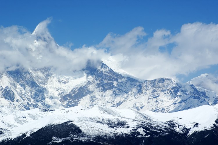
Namcha Barwa’s profile varies considerably according to the direction from which it is seen. From western viewpoints, it commonly appears as a sharp, snow-covered pyramid rising above lower ridges. From other angles, the summit is revealed as part of a more complicated system of steep faces, subsidiary summits, connecting ridges, glaciers, and avalanche channels.
The mountain is sometimes called the “Shy Mountain” or “Shy Maiden Peak” because clouds frequently conceal its summit. Moist air moving northward from the Indian subcontinent is forced upward against the eastern Himalayas, encouraging heavy precipitation and persistent cloud formation around the massif.
The name is commonly interpreted as meaning a “spear piercing the sky,” an image that reflects the pointed form of the summit. Other translations and traditional interpretations include associations with thunder, lightning, or burning fire, illustrating the difficulty of reducing Tibetan place-names and oral traditions to a single English phrase.
Unlike Everest, Annapurna, or several of the Karakoram giants, Namcha Barwa has never developed into a major commercial mountaineering destination. It remains better known for its extraordinary landscape, geological importance, cultural setting, and elusive views than for repeated expeditions to its summit.

⚡ Fast Facts
| Fact | Details |
|---|---|
| Continent | Asia |
| Country | China |
| Autonomous region | Tibet Autonomous Region |
| Prefecture-level city | Nyingchi |
| County/region | Commonly placed in Mêdog County; western viewpoints and approaches are associated with Mainling |
| Traditional region | Pemako |
| Mountain range | Himalayas |
| Subrange | Namcha Barwa Himal, also classified as part of the Assam Himalaya |
| Parent peak | Kangchenjunga |
| Elevation | 7,782 m / 25,531 ft |
| Topographic prominence | 4,106 m / 13,471 ft |
| Topographic isolation | 706.89 km / 439.24 mi |
| Nearest Higher Neighbor | Kangchenjunga South, west-southwest of Namcha Barwa |
| Coordinates | Approximately 29.6290° N, 95.0559° E |
| Worldwide elevation rank | 27th |
| Worldwide prominence rank | 19th |
| Himalayan prominence rank | 3rd, after Mount Everest and Nanga Parbat |
| Mountain classification | Ultra-prominent peak |
| Major nearby peak | Gyala Peri, 7,294 m |
| First ascent | October 30, 1992 |
| First-ascent expedition | Joint Chinese-Japanese expedition |
| Historic climbing route | South ridge by way of Nai Peng or Naipun |
| Drainage basin | Yarlung Tsangpo–Brahmaputra system |
The measurements, rankings, parentage, isolation, and nearest-higher-neighbor information above follow Peakbagger’s current topographic data. Administrative descriptions vary because the massif lies near the mountainous transition between Mêdog and Mainling, while many of the best-known western viewing locations are in Mainling. (Peakbagger)
📍 Location
Southeastern Tibet
Namcha Barwa lies in southeastern Tibet, considerably farther east than the Himalayan giants of Nepal, Sikkim, and central Tibet. The summit is approximately situated at 29.629° north latitude and 95.056° east longitude, within the deeply dissected terrain of Nyingchi.
The mountain is commonly assigned to Mêdog County, although its western side is closely associated with neighboring Mainling. This sometimes produces apparently conflicting location descriptions. The summit and much of the southeastern massif are connected geographically with Mêdog and Pemako, while widely visited observation areas such as the Yarlung Tsangpo Grand Canyon viewpoints and villages west of the mountain are reached through Mainling.
The surrounding terrain is among the most rugged in Asia. Roads and settlements generally occupy river valleys or elevated terraces, while the mountain itself rises beyond a maze of forested slopes, side valleys, glaciers, cliffs, and subsidiary ridges. Even reaching a clear viewpoint can require substantial travel through the Nyingchi region.
The Great Bend of the Yarlung Tsangpo
Namcha Barwa’s position beside the Great Bend of the Yarlung Tsangpo is central to its identity. The river flows eastward across southern Tibet before encountering the eastern Himalayan syntaxis. It then makes a sweeping bend around the Namcha Barwa–Gyala Peri region and turns generally southward through the Yarlung Tsangpo Grand Canyon.
After crossing into India, the river is known principally as the Siang or Dihang before joining other major rivers and becoming the Brahmaputra. Namcha Barwa therefore overlooks one of Asia’s most important river systems, whose waters eventually cross northeastern India and Bangladesh before reaching the Bay of Bengal.
The relationship between mountain and river creates enormous local relief. Namcha Barwa rises thousands of meters above nearby valleys, with some descriptions placing the total vertical difference between the summit and the lowest surrounding river terrain at more than 6,000 meters. The exact figure depends on which point in the gorge is used, but the landscape unquestionably contains one of the most dramatic transitions from subtropical valley forest to permanent snow and ice anywhere in the Himalayas.
The Eastern End of the Himalayas
The Himalayas do not end at a perfectly defined line. Nevertheless, geographers and mountaineers have traditionally described the range as extending from the Indus River near Nanga Parbat in the west to the Brahmaputra or Yarlung Tsangpo near Namcha Barwa in the east.
Under this convention, Namcha Barwa is the eastern anchor of the Himalayan mountain system. The peak stands where the general east-west trend of the central Himalayas curves sharply toward the south. This bend is not merely a feature on a map; it reflects the complicated deformation of the crust around the northeastern edge of the Indian Plate.
Mountains continue east of the Yarlung Tsangpo gorge, including ranges connected with the southeastern Tibetan Plateau and the Hengduan mountain system. These eastern ranges are geologically related to the wider collision between India and Eurasia, but they are not normally classified as part of the main Himalayan chain.
Namcha Barwa and Gyala Peri
Across the Yarlung Tsangpo gorge, approximately 22 kilometers north-northwest of Namcha Barwa, stands Gyala Peri, a 7,294-meter mountain belonging to the Nyenchen Tanglha system. Together, the two peaks tower above opposite sides of the river corridor.
Gyala Peri is lower than Namcha Barwa, but it is a major mountain in its own right. The closeness of two such high summits, combined with the immense canyon between them, contributes to the exceptional scale of the landscape. In photographs and satellite images, the river appears to pass through a gateway guarded by the two massifs.
The pair also demonstrates the geological complexity of the eastern syntaxis. Although the mountains stand close together, they occupy different structural positions within the broader collision zone and are separated by one of the most deeply incised river systems in High Asia.
🏔️ Field Guide Tip: Clouds can hide Namcha Barwa for entire days, even when surrounding valleys appear reasonably clear. Travelers hoping to see the summit should allow more than one viewing opportunity rather than building an itinerary around a single morning or overlook.
📏 Elevation & Prominence
How High Is Namcha Barwa?
Namcha Barwa has a generally accepted elevation of 7,782 meters, or 25,531 feet, above sea level. This places it 27th among the world’s mountains when independent summits are ranked by elevation. It is also the highest mountain in the Namcha Barwa Himal and the highest point in the easternmost section of the conventional Himalayan range.
Older maps and publications have occasionally listed elevations such as 7,755, 7,756, 7,782, or 7,787 meters. Such discrepancies are common among remote Himalayan mountains because early figures were based on different surveys, map datums, instruments, and interpretations of the summit position. The 7,782-meter figure is now the value most commonly used by modern topographic databases and mountaineering references.
Namcha Barwa is almost 1,070 meters lower than Mount Everest, but elevation alone does not communicate its visual scale. Much of the Tibetan Plateau surrounding Everest already lies several thousand meters above sea level. Namcha Barwa, by contrast, rises above valleys that descend toward moist, densely forested terrain. Consequently, its vertical rise above its immediate surroundings can appear even more dramatic.
Topographic Prominence
Namcha Barwa has a topographic prominence of approximately 4,106 meters, or 13,471 feet. Prominence measures how far a mountain rises above the lowest saddle connecting it to higher terrain. It therefore describes the mountain’s independence from surrounding peaks rather than its height above sea level.
A prominence exceeding 4,000 meters is extremely unusual. Namcha Barwa ranks approximately 19th in the world by prominence and third within the Himalayas, behind only Mount Everest and Nanga Parbat. Its prominence is greater than that of many better-known mountains, including K2.
Namcha Barwa’s key col is identified as Lo La, at approximately 3,676 meters. Its line parent is Kangchenjunga, meaning that Kangchenjunga is the higher summit reached when Namcha Barwa’s prominence relationship is traced across the intervening landscape.
Isolation and Nearest Higher Neighbor
The mountain has a topographic isolation of approximately 706.89 kilometers, or 439.24 miles. This is the distance one must travel from Namcha Barwa before reaching terrain of equal or greater elevation.
Peakbagger identifies Kangchenjunga South, located west-southwest of Namcha Barwa, as its nearest higher neighbor. The great distance separating the two emphasizes how thoroughly Namcha Barwa dominates the eastern Himalayas. No nearby summit reaches its elevation, despite the presence of numerous 6,000- and 7,000-meter peaks.
An Ultra-Prominent Mountain
Any mountain with at least 1,500 meters of prominence is classified as an ultra-prominent peak, often shortened to an “Ultra.” Namcha Barwa exceeds that threshold by more than 2,600 meters.
Its combination of height, prominence, isolation, and immediate relief makes it one of the world’s most topographically significant mountains. Several Himalayan summits are higher, but relatively few stand so independently or rise so abruptly above their surrounding valleys.
🪨 Geology
The Eastern Himalayan Syntaxis
Namcha Barwa occupies the heart of the eastern Himalayan syntaxis, one of the most important geological structures in Asia. A syntaxis is a region where the dominant direction of a mountain belt changes abruptly and major folds, faults, and rock units converge or curve around one another.
Across much of Nepal and northern India, the Himalayas form a broad arc extending roughly northwest to southeast. Near Namcha Barwa, this structural trend bends sharply toward the south. A comparable bend occurs near Nanga Parbat at the western end of the range.
The eastern syntaxis formed within the wider collision zone between the Indian and Eurasian tectonic plates. India’s northward movement compressed, thickened, folded, faulted, metamorphosed, and uplifted the crust, creating the Himalayas and contributing to the elevation of the Tibetan Plateau.
At Namcha Barwa, these forces are concentrated within a complicated knot of crustal structures. The region includes a high-pressure metamorphic complex and a migmatitic dome—rocks that were once buried deep within the crust, altered by intense heat and pressure, and in some places partially melted.
Deep Crust Exposed at the Surface
Geological investigations show that rocks now exposed around Namcha Barwa originated at substantial depths. Metamorphic and geochronological evidence indicates that deeply buried material has been brought toward the surface at exceptionally rapid rates, particularly during the later stages of Himalayan development.
Some studies suggest that rocks formerly buried roughly 30 kilometers beneath the surface were exhumed during the last several million years. Other research documents young mineral-growth and cooling ages, supporting a history of rapid uplift, erosion, and exposure during the late Miocene, Pliocene, and Pleistocene.
This makes Namcha Barwa a natural laboratory for studying exhumation—the process by which rocks are brought from deep within the crust toward Earth’s surface. Exhumation may involve tectonic uplift, fault movement, folding, erosion, and the removal of overlying material.
Tectonics and River Erosion
The Yarlung Tsangpo plays a major role in shaping the massif. The river and its tributaries cut deeply into rising terrain, stripping away rock and transporting sediment downstream. As erosion removes material from the surface, deeper rocks can continue moving upward and become exposed.
This interaction inspired the influential tectonic aneurysm model. Under this interpretation, concentrated river erosion removes rock from a relatively small area, encouraging deeper, hot, and mechanically weakened crust to rise more rapidly. Continued uplift produces steeper slopes, which in turn encourage landslides and additional erosion.
Namcha Barwa and Nanga Parbat have often been cited as the two leading Himalayan examples of this process. However, the exact relationship between river incision and tectonic uplift remains debated. Evidence for an ancient canyon buried beneath younger sediments indicates that part of the Yarlung Tsangpo’s course existed before the most recent phase of rapid exhumation, complicating any simple claim that the modern gorge alone initiated the uplift.
The most accurate interpretation is therefore one of interaction rather than a single cause. Regional plate collision, crustal structure, folding, faulting, uplift, river incision, monsoon precipitation, landslides, and glacial erosion all contribute to the present landscape.
Metamorphic Rocks and Partial Melting
The core of the Namcha Barwa syntaxis contains intensely metamorphosed rocks derived largely from continental crust. These include high-grade gneissic and migmatitic materials that record extreme temperatures, pressures, deformation, and partial melting.
A gneiss is a metamorphic rock characterized by compositional banding produced under high temperatures and pressures. A migmatite records conditions so hot that parts of the original metamorphic rock began to melt. Their presence indicates that portions of the Namcha Barwa massif were once situated deep within thickened Himalayan crust.
As the rocks rose and cooled, minerals within them preserved evidence of their changing temperature and pressure. Geologists can date these minerals to reconstruct when the rocks were buried, heated, deformed, partially melted, uplifted, and exposed.
Research from the syntaxis indicates that this history was neither steady nor simple. Multiple phases of metamorphism, deformation, uplift, and cooling occurred as the eastern end of the Himalayas evolved.
One of Asia’s Great Sediment Sources
Namcha Barwa is also an important source of sediment for the Yarlung Tsangpo and Brahmaputra rivers. Steep slopes, fractured bedrock, powerful monsoon rainfall, glacial activity, and frequent landslides allow the surrounding landscape to erode rapidly.
Mineral grains eroded from the massif can be identified far downstream. Studies of river sands show that the Namcha Barwa syntaxis contributes a disproportionately large amount of material to the Brahmaputra sediment system. Some researchers have consequently described it as an extraordinary “sediment factory.”
These sediments eventually travel through northeastern India and Bangladesh, helping build river floodplains and contributing material to the vast Bengal sedimentary system. Namcha Barwa is therefore connected not only to the high mountains of Tibet but also to landscapes hundreds or thousands of kilometers downstream.
A Landscape Still Being Built
Namcha Barwa is not simply the eroded remains of an ancient, inactive mountain. The region continues to experience tectonic stress, earthquakes, landslides, river incision, and erosion. Its valleys and ridges remain part of a developing mountain landscape.
Over geological time, uplift raises rock while rivers, glaciers, rainfall, frost, and gravity wear it down. The mountain visible today represents the temporary result of this competition. Namcha Barwa’s extraordinary elevation and relief show that crustal uplift has been extremely powerful, while its deep gorges and enormous sediment output demonstrate that erosion is equally relentless.

🌿 Flora & Fauna
An Extraordinary Elevation Gradient
The Namcha Barwa region contains one of the most dramatic ecological transitions in the Himalayas. Within a relatively short horizontal distance, the landscape rises from warm, humid river valleys to a permanently frozen summit more than 7,700 meters above sea level.
This enormous elevation difference allows plant communities normally separated by thousands of kilometers of latitude to occur almost one above another. Lower valleys support vegetation with tropical and subtropical characteristics, while higher slopes pass through broadleaf forests, conifer forests, alpine shrublands, meadows, sparse subnival vegetation, glaciers, and finally bare rock and permanent snow.
Scientific studies of the southern Yarlung Tsangpo Grand Canyon have identified a sequence of major vegetation belts that includes:
- Evergreen and semi-evergreen monsoon rainforest
- Evergreen broadleaf forest
- Semi-evergreen broadleaf forest
- Hemlock forest
- Fir forest
- Alpine shrubland and meadow
- Sparse subnival vegetation
- A high nival zone dominated by snow, ice, and exposed rock
The precise elevation of each belt changes according to slope direction, moisture, local topography, and distance from the main river. Nevertheless, the region possesses one of the most complete vertical vegetation sequences documented in China and one of the most remarkable in the world.
Monsoon Forests of the Lower Valleys
The lower reaches of the Yarlung Tsangpo and its tributaries receive warm, moisture-laden air moving northward from the Indian subcontinent. The deep gorge acts as a corridor through which this humid air penetrates the southeastern Tibetan Plateau.
At the lowest elevations around Mêdog, the climate is unusually warm and wet for Tibet. Dense forests contain evergreen broadleaf trees, tree ferns, vines, mosses, orchids, and other moisture-loving plants more commonly associated with the eastern Himalayas and northeastern India than with the dry interior of the Tibetan Plateau.
Trees and shrubs represented within the wider canyon landscape include magnolias, laurels, oaks, maples, hollies, rhododendrons, and members of the tea family. Tree ferns and thick understory vegetation occur in especially humid locations.
The forest floor may be covered by ferns, mosses, fungi, and decaying vegetation. Epiphytes grow on tree trunks and branches, while climbing plants compete for access to light in the forest canopy.
These lower forests are ecologically important because they connect the plant communities of the Tibetan Plateau with those of northeastern India, Bhutan, northern Myanmar, and southwestern China. Species from several major biogeographic regions overlap here, contributing to the area’s unusual diversity.
Temperate Broadleaf and Mixed Forests
As elevation increases, tropical and subtropical vegetation gives way to cooler broadleaf forests. Oaks, maples, birches, magnolias, and rhododendrons become increasingly prominent, often mixed with conifers.
These middle-elevation forests experience abundant precipitation, frequent fog, and cool temperatures. Moss may cover tree trunks, rocks, and fallen branches, producing the appearance of a temperate cloud forest.
Rhododendrons are particularly characteristic of the eastern Himalayas. Different species occur from relatively warm forest environments to exposed alpine slopes, producing flowers in shades of white, pink, red, and purple.
The great variety of flowering plants attracted several early explorers and botanists to the region. British plant collector and geographer Frank Kingdon-Ward, who explored parts of southeastern Tibet during the early 20th century, helped make the forests near Namcha Barwa famous among Western botanists.
The area became especially associated with Himalayan blue poppies. These striking flowers belong to the genus Meconopsis and thrive in cool, moist mountain environments. They are not restricted to Namcha Barwa, but they became closely connected with early written accounts of the mountain and its surrounding valleys.
Conifer Forests
At higher elevations, fir, hemlock, spruce, and other conifers become dominant. The exact forest composition varies between the wetter southern slopes, the somewhat drier northern approaches, and sheltered tributary valleys.
Subalpine forests may appear dark and dense, with tall conifers rising above an understory of rhododendrons, bamboo, shrubs, mosses, and ferns. Persistent cloud and high humidity allow thick layers of lichen and moss to grow on branches.
Some of the most remarkable trees in Asia have been documented in the wider Yarlung Tsangpo Grand Canyon. Surveys using ground measurements, drones, and laser-scanning technology have located exceptionally tall South Tibetan cypress trees in remote forests. The presence of these giant trees demonstrates the combination of high rainfall, deep soils, relatively mild valley temperatures, and long periods of forest continuity found in parts of the canyon.
The giant-tree forests do not extend onto Namcha Barwa’s upper slopes, but they form part of the same enormous ecological system surrounding the mountain and the Great Bend of the Yarlung Tsangpo.
Alpine Shrublands and Meadows
Above the continuous forest, trees become shorter, more widely spaced, and increasingly distorted by wind, snow, and cold. Eventually, the forest gives way to alpine shrubs and meadows.
Low-growing rhododendrons, junipers, dwarf willows, sedges, grasses, and cushion plants occupy these exposed environments. During the brief summer, alpine meadows may produce a concentrated display of wildflowers.
Plants at these elevations must tolerate:
- Long periods beneath snow
- Strong ultraviolet radiation
- Thin soils
- Frequent frost
- High winds
- Sudden temperature changes
- A very short growing season
Many species remain close to the ground, where temperatures are slightly warmer and winds are less destructive. Others grow in compact cushions or rosettes that help conserve heat and moisture.
The alpine zone provides seasonal grazing habitat for wild ungulates and supports insects, small mammals, and birds adapted to cold, open environments.
The Subnival and Nival Zones
Vegetation becomes increasingly sparse above approximately 4,400 to 4,800 meters. Only highly specialized plants can survive in sheltered cracks, gravel beds, or ice-free patches.
Above this transitional zone, Namcha Barwa is dominated by glaciers, permanent snowfields, steep rock faces, and avalanche slopes. There is effectively no continuous vegetation on the upper mountain.
Even in the nival zone, however, life is not entirely absent. Algae, lichens, microbes, and microscopic organisms may survive on exposed rock, in snow, or within meltwater environments.
The location of the upper vegetation limit is influenced by temperature, precipitation, snow persistence, slope exposure, and local wind conditions. Climate change may gradually alter these boundaries, but the response will not necessarily be uniform across such a steep and complex mountain landscape.
Mammals of the Namcha Barwa Region
Namcha Barwa’s forests form part of one of the richest mammal habitats on the Tibetan Plateau. Recent camera-trap surveys in Mêdog and the Yarlung Tsangpo Grand Canyon have recorded an unusually diverse community of carnivores, primates, ungulates, and smaller mammals.
Species documented within the wider protected landscape include:
- Clouded leopard
- Asiatic golden cat
- Marbled cat
- Leopard cat
- Dhole
- Himalayan black bear
- Himalayan red panda
- Takin
- Himalayan serow
- Red goral
- Northern red muntjac
- Wild boar
- Assam macaque
- Capped langur
- White-cheeked macaque
- Yellow-throated marten
Not every species occurs at every elevation or on the slopes of Namcha Barwa itself. The list represents the wider canyon and Mêdog ecosystem, where habitat ranges from low, humid forest to alpine terrain.
Clouded leopards inhabit densely forested environments and are rarely seen. Asiatic golden cats display considerable variation in coat color and pattern, while red pandas are associated primarily with cool mountain forests containing bamboo and suitable tree cover.
Takin, serow, and goral are adapted to steep terrain. Their strong limbs and specialized hooves allow them to move across forested slopes, cliffs, and rocky mountain environments that would be difficult for many other large mammals.
Camera-trap studies have also shown that human activity can influence how animals use the landscape. Roads, livestock, domestic dogs, settlements, and foot traffic may change the distribution or activity patterns of sensitive species.
Birds and Other Wildlife
The extreme range of elevations and habitats surrounding Namcha Barwa supports a rich bird community. Forest species occupy the warm valleys, while pheasants, raptors, finches, accentors, and other mountain birds occur higher on the slopes.
Notable birds recorded in the broader southeastern Tibetan region include Himalayan monals, Sclater’s monals, blood pheasants, Tibetan eared pheasants, laughingthrushes, babblers, sunbirds, parrotbills, and several species of eagle.
The forests also support an unusually varied collection of amphibians, reptiles, butterflies, moths, and other invertebrates. Scientific surveys continue to document species previously unknown to science or not formerly recorded in Tibet.
One example is the Namcha Barwa slender-tongued frog, Liurana namchabarwa. The small frog was described from mountain forest in Mêdog and named for Namcha Barwa. It inhabits cool, moist forest near approximately 2,500 meters, demonstrating how the mountain has become part of the scientific identity of newly documented wildlife.
A Meeting Place of Biological Regions
The biodiversity of the Namcha Barwa area results partly from its location near the boundary of several major ecological regions. Species associated with the Tibetan Plateau, the eastern Himalayas, southwestern China, and the humid forests of northeastern India all occur within the broader landscape.
Deep valleys provide routes by which warm-climate plants and animals can move northward, while high ridges support cold-adapted Himalayan and Tibetan species. Isolated side valleys, steep elevation gradients, and varied microclimates encourage populations to become separated from one another, sometimes leading to the development of distinct local forms or species.
This mixture makes the Namcha Barwa–Mêdog region particularly important for research into evolution, species distribution, climate adaptation, and mountain ecology.
Conservation Challenges
Much of the landscape surrounding Namcha Barwa remains forested, but its ecosystems face increasing pressure from road construction, tourism, resource use, climate change, and the expansion of human activity into previously remote valleys.
Landslides, earthquakes, floods, and other natural disturbances are normal components of the environment. Human development can nevertheless magnify their effects by fragmenting habitat or destabilizing slopes.
Conservation is particularly difficult because the landscape is enormous, steep, wet, and hard to survey. Many species remain poorly understood, and some may have extremely limited distributions.
The Yarlung Tsangpo Grand Canyon National Nature Reserve protects a substantial portion of the region. Continued biological surveys, wildlife monitoring, forest protection, and cooperation with local communities will be essential for preserving its ecological diversity.
🥾 Hiking & Climbing Routes
Can Namcha Barwa Be Hiked?
Namcha Barwa is not a conventional hiking mountain. There is no maintained recreational trail to the summit, no tourist base camp comparable to those at Everest or Annapurna, and no established commercial climbing industry.
Most visitors experience the mountain from distant roads, villages, scenic areas, or high passes. Travel in the region may involve short walks to observation platforms, village paths, forest trails, and sections of the Yarlung Tsangpo Grand Canyon, but these should not be confused with an ascent of Namcha Barwa.
The mountain’s upper slopes are appropriate only for elite expedition mountaineers. Even reaching the foot of a possible climbing route would require complicated logistical arrangements, local authorization, experienced support, and travel through extremely remote terrain.
Access rules in southeastern Tibet can change, and some areas are restricted. Travelers should confirm current regulations through an authorized local operator before planning a visit.
Why Namcha Barwa Is So Difficult
Namcha Barwa is lower than the world’s 8,000-meter peaks, but it presents a combination of difficulties that make it one of the most formidable mountains in Asia.
Major hazards include:
- Enormous vertical relief
- Long and complicated approaches
- Heavy snowfall
- Frequent cloud and fog
- Rapid weather changes
- Avalanche-prone ridges
- Steep snow and ice
- Difficult rock bands
- Corniced ridgelines
- Deep, unconsolidated snow
- Limited opportunities for rescue
- Restricted access
- Dense forests and unstable slopes at lower elevations
Its location near a major monsoon corridor is especially important. Moisture moving through the Yarlung Tsangpo gorge produces frequent snowfall on the mountain, while warmer valley conditions can contribute to unstable snowpacks and avalanche activity.
The mountain also lacks a relatively straightforward side. Early reconnaissance climbers identified several possible lines, but each involved complicated combinations of rock, snow, ice, ridges, subsidiary summits, and avalanche terrain.
Early Exploration
Namcha Barwa was identified and mapped by outsiders during early explorations of the Yarlung Tsangpo region in the 1910s. British explorers including Frederick Marshman Bailey and Henry Morshead investigated the Tsangpo’s course and helped establish the mountain’s geographic position.
The massif nevertheless remained largely inaccessible to mountaineers for much of the 20th century. Political restrictions, the remoteness of southeastern Tibet, inadequate maps, and the difficulty of reaching the mountain prevented the kind of repeated expeditions seen on peaks in Nepal and Pakistan.
Chinese scientific and mountaineering teams began systematic reconnaissance during the early 1980s. Expeditions investigated the region’s climate, flora, fauna, geography, and possible climbing lines.
The Ascent of Nai Peng
A major subsidiary summit called Nai Peng, also written Naipun or Naipeng, rises along Namcha Barwa’s southern approach. Its elevation is generally given as approximately 7,043 meters.
Chinese climbers investigated the mountain in 1983 and 1984. In April 1984, they climbed Nai Peng’s steep and avalanche-prone southwestern side. Seven climbers reached its summit and used the vantage point to examine possible routes on Namcha Barwa.
From Nai Peng, the team determined that the main mountain offered several potential lines, but all appeared technically complicated and exposed to serious objective danger.
Nai Peng would eventually become a central feature of the successful route. Rather than bypassing the subsidiary mountain, later expeditions climbed onto or across its ridge before descending toward the col separating it from Namcha Barwa.
The 1990 Reconnaissance
In 1990, a joint Chinese-Japanese team examined the west-northwest ridge. The climbers rejected that line because of uncertain snow conditions and frequent avalanches.
They then returned to the southern approach previously studied by Chinese teams. The expedition established camps on the ridge leading toward Nai Peng and found a way to descend to the approximately 6,700-meter col between Nai Peng and Namcha Barwa.
Finding this passage was a major breakthrough. Previous teams had been unable to determine how to cross the complicated terrain between the subsidiary peak and the main mountain.
The reconnaissance established the basic line that would be followed during the 1991 and 1992 expeditions.
The 1991 Attempt and Avalanche
A joint Chinese-Japanese expedition returned in 1991. The team climbed the southern approach, established a series of camps, crossed Nai Peng, and descended to the col below the main summit.
The expedition suffered a tragedy when Japanese climber Hiroshi Onishi was killed by an avalanche on October 18.
After suspending activity for approximately ten days, the team resumed the climb. Camps were eventually established as high as the col, and fixed ropes were placed above 7,000 meters.
Climbers overcame a difficult rock band at approximately 7,350 meters but encountered deep, unstable snow and severe avalanche danger above it. On November 24, the expedition turned around only about 220 vertical meters below the summit.
Strong winds, repeated snowfall, and the arrival of winter made further progress unacceptably dangerous.
The First Ascent in 1992
The climbers returned for another attempt in the autumn of 1992. The joint expedition consisted of six Japanese and six Chinese climbing members, supported by a much larger logistical team.
Learning from the previous year, the expedition began climbing in mid-September to take advantage of the period immediately following the summer monsoon. Even then, storms and heavy snow interrupted progress and defeated two early summit attempts.
The expedition again followed the southern route over Nai Peng. Six principal camps were established, with the highest located near the col at approximately 6,700 meters.
On October 29, the weather finally improved. Climbers left the highest camp, crossed steep mixed terrain, and worked through the difficult rock band. Deep snow above the band slowed them dramatically.
Unable to reach the summit before dark, members of the first team bivouacked at approximately 7,600 meters. Conditions were unusually calm and clear during the night.
The next morning, October 30, the climbers continued through deep snow toward the upper ridge. The first group reached the summit at 12:09 p.m., followed by a second group at approximately 2:30 p.m.
A total of eleven expedition members reached the summit that day. The ascent ended Namcha Barwa’s status as the world’s highest unclimbed independent mountain.
The Historic South-Ridge Route
The 1992 route is generally described as the south or south-southwest ridge, although the complete line was more complicated than that name suggests.
The route involved:
- Establishing base camp at approximately 3,500 meters.
- Ascending steep forested and glaciated terrain toward the southern ridge.
- Climbing onto Nai Peng.
- Traversing or descending from Nai Peng toward the connecting col.
- Establishing the highest camp near 6,700 meters.
- Ascending the lower slopes of Namcha Barwa.
- Overcoming the prominent rock band at approximately 7,350 meters.
- Climbing deep snow toward the upper north-northeast ridge.
- Following the final ridge to the summit.
The route combined snow, ice, and rock rather than following a single glacier or continuous snow ridge. It also required climbers to lose elevation after crossing Nai Peng before beginning the final ascent of Namcha Barwa.
This substantial elevation loss increased the physical demands of the route and complicated the movement of equipment between camps.
The Difficult Rock Band
The rock band near 7,350 meters was one of the most technically important sections of the ascent. During the 1991 attempt, climbers reached and passed this obstacle but were stopped by unstable snow above it.
In 1992, expedition members again had to work through the band using fixed ropes. Beyond the rock, they encountered deep snow that sometimes reached waist level.
At such elevations, breaking trail through deep snow is extremely exhausting. Climbers move slowly because of reduced oxygen, cold temperatures, heavy clothing, and the need to assess avalanche conditions continuously.
The combination of technical rock below and unstable snow above left the climbers with few safe options for rapid movement or retreat.
Weather Forecasting and the Successful Ascent
Weather analysis was a critical element of the 1992 expedition. A meteorological specialist at base camp examined local observations and satellite information supplied from Japan.
This forecasting allowed the climbers to remain at high camp through bad weather with some confidence that a clearing period was approaching. When conditions improved on October 29, the summit teams were prepared to move.
The success demonstrated how greatly Himalayan expedition tactics had changed by the early 1990s. Satellite weather data could not eliminate danger, but it helped the team identify a rare opening in Namcha Barwa’s unstable autumn conditions.
Has Namcha Barwa Been Climbed Again?
No confirmed repeat ascent has been widely documented since the 1992 expedition. Mountaineering histories and climbing indexes continue to describe the Chinese-Japanese climb as the mountain’s only confirmed ascent.
Restrictions on climbing, logistical difficulty, cultural concerns, political sensitivity, and extreme objective danger have all limited further attempts. The absence of repeated ascents makes Namcha Barwa highly unusual among mountains of comparable elevation.
Because expedition records from restricted areas can be incomplete, it is safest to describe the 1992 climb as the only confirmed and widely recognized ascent, rather than claiming that no person could possibly have returned.
A Mountain Beyond Commercial Mountaineering
Namcha Barwa has never become part of the commercial high-altitude climbing circuit. There are no regular guided departures, established permit seasons, stocked base camps, permanent route infrastructure, or large groups of clients.
This has protected the mountain from some of the crowding and waste problems affecting more accessible Himalayan peaks. It also means that any future expedition would face a largely self-contained challenge.
A team would need advanced ability in mixed climbing, avalanche assessment, expedition medicine, route finding, fixed-rope management, remote communications, and high-altitude rescue. Even with those skills, permission to attempt the mountain might not be available.
🏔️ Field Guide Tip: Namcha Barwa should be treated primarily as a mountain-viewing destination, not as a trekking summit. Travelers can experience its scale safely from established villages, roads, passes, and canyon viewpoints without approaching the hazardous climbing terrain.

🌤️ Best Time to Visit
October to April: The Clearest Viewing Season
The best period for seeing Namcha Barwa is generally October through April, when southeastern Tibet experiences drier and more stable conditions than during the summer monsoon.
Clear views are never guaranteed. The summit creates its own cloud, and moist air can conceal the mountain even during otherwise fine weather. Nevertheless, autumn, winter, and early spring usually offer the greatest chance of seeing the entire peak.
October and November are particularly attractive because the summer rains have diminished, skies may become clearer, and the most severe winter cold has not yet arrived.
December through February can produce exceptionally crisp views, but temperatures are low, daylight is shorter, and snow may affect high roads and passes.
March and April offer somewhat milder conditions. April is especially popular because the Nyingchi region’s peach trees bloom while Namcha Barwa remains heavily covered in snow.
The Summer Monsoon
The wettest period generally extends from approximately May through September. Warm, humid air moves northward through the Brahmaputra–Yarlung Tsangpo corridor and rises against the eastern Himalayas.
This creates:
- Frequent rain
- Persistent low cloud
- Fog
- Heavy snowfall at high elevations
- Reduced mountain visibility
- Mudslides and landslides
- Difficult road conditions
- Swollen rivers and streams
The landscape is exceptionally green during summer, and wildflowers may be abundant. However, travelers whose main goal is an unobstructed view of Namcha Barwa face a significantly lower chance of success.
July and August are generally among the most difficult months for seeing the summit. The mountain may remain hidden for days behind thick cloud.
Autumn
Autumn is often the best overall season for mountain photography. After the monsoon weakens, reduced humidity can produce clearer skies, while forests display changing colors.
October offers a good balance between visibility, moderate daytime temperatures, and accessible roads. November is colder but may have even clearer air.
Late-afternoon light can illuminate the snowfields in shades of gold, orange, and pink. This phenomenon is frequently called the Golden Mountain or Sunlit Golden Mountain effect.
The spectacle may last only a few minutes. Cloud around the summit can also form or disappear quickly, so photographers should be prepared well before sunset.
Winter
Winter offers some of the year’s clearest atmospheric conditions. Cold, dry air may reveal details of the mountain that are hidden by haze during warmer months.
The disadvantages are low temperatures, icy roads, snow at high passes, and reduced comfort in rural areas. Sejila Pass and other high viewpoints can experience severe wind chill.
Travelers should bring insulated clothing, gloves, a warm hat, eye protection, and footwear suitable for snow or ice. Vehicle plans should allow for delays caused by winter road conditions.
Although Nyingchi lies lower than much of central Tibet, many Namcha Barwa viewpoints are still at elevations capable of causing altitude sickness.
Spring
March and April bring longer days and gradually warming temperatures. Snow remains on the high mountains, while lower valleys begin to show spring vegetation.
The Nyingchi Peach Blossom Festival typically attracts visitors during this period. Villages, fields, and river valleys may be filled with pink blossoms beneath distant white peaks.
April is often promoted as one of the most scenic months for combining Namcha Barwa viewing with the cultural and natural attractions of Nyingchi. Visibility remains unpredictable, however, and occasional rain or cloud can still obscure the mountain.
Allow More Than One Viewing Opportunity
Namcha Barwa is famous for remaining hidden. A traveler who spends only a few minutes at one viewpoint may see nothing more than cloud, while someone who waits several hours—or returns the next day—may witness the entire summit emerge.
An itinerary centered on the mountain should include at least two opportunities for viewing. Spending one or more nights near the canyon or in a village facing the peak provides a better chance than making a hurried roadside stop.
Cloud often changes rapidly around sunrise and sunset. A summit hidden throughout the afternoon can appear shortly before dusk, while a clear morning view may disappear within minutes.
Best Time of Day
The ideal time depends on the chosen viewpoint, but early morning and late afternoon generally provide the most attractive light.
Morning may bring calmer air and fewer clouds in some valleys. Late afternoon and sunset are especially valued for warm light on the mountain’s western and southwestern faces.
Photographers should arrive early enough to select a position and prepare equipment. The brightest golden light may last only 10 to 20 minutes.
A telephoto lens is useful because most public viewpoints are a considerable distance from the summit. A wider lens can capture the relationship between Namcha Barwa, the river, villages, forests, and the walls of the canyon.
🏔️ Field Guide Tip: Plan at least two mornings or evenings near Namcha Barwa. Its cloud cover is so unpredictable that an extra day may make the difference between seeing only mist and witnessing the complete summit.
🧭 Nearby Mountains & Attractions
Yarlung Tsangpo Grand Canyon
The Yarlung Tsangpo Grand Canyon is the defining natural feature surrounding Namcha Barwa. The river bends around the massif before descending through an immense system of gorges toward Mêdog and northeastern India.
The canyon is often described as one of the world’s deepest. Its extraordinary vertical scale results from the difference between the low river valley and the summits of Namcha Barwa and Gyala Peri.
Visitors can experience selected parts of the canyon from roads, villages, scenic platforms, and developed visitor areas. The inner gorge remains extremely remote, hazardous, and difficult to access.
The canyon provides more than dramatic scenery. It is also a major pathway for moisture, plants, animals, and human travel between the Tibetan Plateau and the humid regions to the south.
Gyala Peri
Gyala Peri rises across the Yarlung Tsangpo from Namcha Barwa. Its accepted elevation is approximately 7,294 meters, making it one of the highest mountains in southeastern Tibet.
Although the two peaks are often described as companions, they stand on opposite sides of the gorge and belong to different mountain structures. Together, they form one of the most spectacular high-mountain gateways in Asia.
Gyala Peri is itself extremely difficult and rarely climbed. A Japanese expedition completed its first confirmed ascent in 1986, and it has received very little subsequent mountaineering activity.
From certain viewpoints, Gyala Peri may be partly hidden by intervening ridges, while from others it appears as a vast snowy massif north of the river.
Nai Peng
Nai Peng is the approximately 7,043-meter subsidiary peak used during the first ascent of Namcha Barwa.
It is historically important because Chinese climbers reached its summit in 1984 while evaluating possible routes. The successful 1992 expedition later climbed across its ridge and descended toward the col below Namcha Barwa.
Nai Peng is not a tourist hiking objective. Its slopes are steep, avalanche-prone, glaciated, and deeply connected with the technical climbing history of the main mountain.
Suosong Village
Suosong Village is one of the best-known places from which to view Namcha Barwa. The village occupies an elevated area above the Yarlung Tsangpo and can offer broad views toward the mountain.
Peach blossoms make the area especially popular in spring. In autumn and winter, clearer air may reveal the mountain above fields, forests, and traditional homes.
The exact appearance of Namcha Barwa changes with the weather and the observer’s position. Clouds may conceal the summit while leaving its lower ridges visible, or the peak may briefly appear through an opening shortly before sunset.
Zhibai Village and Canyon Viewpoints
Zhibai, sometimes written Zhibe or Zhibai, lies closer to the inner bend of the canyon and has long been associated with classic western views of Namcha Barwa.
Observation platforms in the wider canyon scenic area provide perspectives of the peak rising above forested ridges. Access policies, road arrangements, and visitor regulations may change, so travelers should confirm the current situation before departure.
The mountain’s apparent shape from these western viewpoints is often sharply pyramidal. In clear conditions, its snowy summit stands dramatically above the darker foreground ridges.
Sejila Pass
Sejila Pass is a high road crossing northwest of Namcha Barwa. Its elevation is approximately 4,700 meters, and it is reached along the highway connecting Nyingchi with areas to the east.
On clear days, the pass provides a distant panoramic view of Namcha Barwa. Prayer flags, open alpine terrain, and broad horizons make it a popular photography stop.
The pass is considerably colder and windier than the valleys below. Visitors arriving from lower elevations should limit strenuous activity and watch for symptoms of altitude sickness.
Namcha Barwa is often hidden even when the sky directly above the pass is blue. Local clouds can remain concentrated around the mountain.
Lulang Forest
Lulang lies west of Sejila Pass and is known for conifer forests, alpine meadows, streams, villages, and mountain scenery.
The area offers a gentler landscape than the inner Yarlung Tsangpo gorge. Forested slopes and open pastures provide a useful contrast to the immense cliffs and deep valleys surrounding Namcha Barwa.
Lulang can be included in a wider Nyingchi itinerary that combines forests, high passes, lakes, villages, and views of the eastern Himalayas.
Nyingchi
Nyingchi serves as the principal travel center for the Namcha Barwa region. The urban area provides accommodations, transportation services, restaurants, shops, and access to major roads.
The region is lower and generally greener than Lhasa. Forests, river valleys, peach orchards, and nearby mountains have earned it a reputation as one of Tibet’s most scenic areas.
Nyingchi is also a useful acclimatization point, although visitors must remember that nearby passes and viewpoints may be more than 1,500 meters higher than the city.
Basum Tso
Basum Tso, also called Basong Lake, is a turquoise alpine lake northwest of Nyingchi. It is surrounded by forested mountains and is culturally important to practitioners of Tibetan Buddhism.
The lake is not directly beside Namcha Barwa, but it is often included in broader journeys through eastern Tibet. Its relatively accessible setting provides a contrast with the remote and severe terrain around the Great Bend.
Mêdog
Mêdog lies south and east of Namcha Barwa in one of Tibet’s warmest and wettest regions. The county is known for deep forests, steep valleys, abundant rainfall, tea production, biodiversity, and communities belonging to several ethnic and cultural traditions.
For much of modern history, Mêdog was among the most difficult county centers in China to reach by road. Improved transportation has changed access, but the terrain remains vulnerable to landslides, flooding, snow, and road closures.
The journey toward Mêdog reveals the tremendous ecological descent from cold Tibetan highlands into humid Himalayan forest. However, travel regulations and road conditions should be checked carefully before planning a visit.
The Great Bend Landscape
The attraction of Namcha Barwa cannot be separated from the wider Great Bend landscape. The mountain, river, forests, glaciers, villages, and opposing ridges form a single interconnected environment.
A visitor does not need to stand close to the summit to understand its scale. In many respects, the most meaningful views are those that show Namcha Barwa rising above the inhabited valleys and forests below.
These perspectives reveal why the mountain is simultaneously a geological landmark, an ecological center, a sacred presence, and one of the most visually powerful summits in the Himalayas.

💡 Fun Facts
Namcha Barwa Marks the Eastern End of the Himalayas
Under the traditional geographic definition, the Himalayas extend between two great river bends: the Indus near Nanga Parbat in the west and the Yarlung Tsangpo–Brahmaputra near Namcha Barwa in the east.
Namcha Barwa is therefore commonly described as the eastern anchor of the Himalayas. The mountain stands where the range curves sharply southward around the northeastern edge of the Indian Plate.
It Is the World’s 27th-Highest Independent Mountain
At 7,782 meters (25,531 feet), Namcha Barwa ranks as the 27th-highest generally recognized independent mountain in the world.
Although it falls more than 200 meters below the 8,000-meter threshold, its exceptional prominence and local relief make it one of Asia’s most imposing mountains.
It Is One of the World’s Most Prominent Peaks
Namcha Barwa has approximately 4,106 meters (13,471 feet) of topographic prominence. It ranks about 19th worldwide by prominence and third within the Himalayas, after Mount Everest and Nanga Parbat.
Its prominence is greater than that of many higher and better-known summits, including K2, Lhotse, Makalu, and Cho Oyu.
The Mountain Rises More Than Six Kilometers Above Nearby Forests
The Yarlung Tsangpo cuts through deeply incised terrain beside the massif. From parts of the surrounding river landscape, Namcha Barwa rises approximately 6,000 to 6,400 vertical meters above densely forested valleys.
Few mountains combine such a high summit with warm, humid forests so close to their base. This extraordinary relief helps create the region’s sequence of subtropical, temperate, subalpine, alpine, and glacial environments.
It Was Once the Highest Unclimbed Independent Mountain
After the first ascent of Batura Sar in 1976, Namcha Barwa was generally regarded as the highest independent mountain that had never been climbed.
That distinction lasted until October 30, 1992, when members of a joint Chinese-Japanese expedition reached the summit. Eleven expedition members reportedly summited in two groups.
It Has Only One Confirmed Ascent
No repeat ascent has been widely confirmed since the successful 1992 expedition. Namcha Barwa is therefore generally described as having been climbed only once.
This is remarkable for a mountain of its elevation. Most of the world’s other major 7,000-meter peaks have received multiple expeditions, while the more accessible ones are climbed regularly.
Namcha Barwa’s isolation, restricted access, avalanche danger, severe weather, and cultural importance have prevented it from developing into a conventional mountaineering destination.
The Successful Route Crossed Another 7,000-Meter Peak
The first-ascent route did not follow a direct line from the valley to the summit. The climbers first ascended the ridge of Nai Peng, a subsidiary mountain of approximately 7,043 meters.
They then descended toward a col at roughly 6,700 meters before beginning the final climb of Namcha Barwa. This loss and regain of elevation considerably increased the route’s physical and logistical difficulty.
Satellite Weather Data Helped Make the First Ascent Possible
A weather specialist at base camp analyzed local conditions together with satellite information transmitted from Japan.
This forecasting helped the summit teams wait through storms at high camp until a brief period of improved weather arrived. The climbers left camp on October 29, bivouacked near 7,600 meters, and reached the summit the following day.
The Meaning of Its Name Is Not Completely Settled
Several English interpretations of Namcha Barwa’s Tibetan name appear in travel, mountaineering, and cultural sources.
Common translations include:
- “Long spear piercing the sky”
- “Burning thunder”
- “Blazing thunderbolt”
- “Stones that fell from heaven”
The variation reflects different transliterations, regional interpretations, and attempts to translate Tibetan words whose meanings may carry symbolic as well as literal associations.
The mountain’s sharp summit has made the spear interpretation especially popular, while early Chinese mountaineering reports recorded the “stones from heaven” translation.
It Is Known as the “Shy Mountain”
Namcha Barwa is frequently called the Shy Mountain or Shy Maiden Peak because clouds often conceal its summit.
The nickname is well suited to the local climate. Moisture moving northward from the Indian subcontinent enters the Yarlung Tsangpo corridor and rises against the eastern Himalayas, producing frequent cloud, fog, precipitation, and high-elevation snowfall.
A traveler may spend several days near the mountain without seeing its complete summit.
It Stands Within the Sacred Landscape of Pemako
Namcha Barwa rises above Pemako, a region understood in Tibetan Buddhist traditions as a beyul, or hidden sacred land.
Accounts of Pemako describe it as a place of spiritual refuge associated with prophecies attributed to Padmasambhava. The region’s mountains, rivers, valleys, caves, and pilgrimage sites are interpreted as parts of a sacred landscape rather than merely physical features.
In some descriptions of this spiritual geography, Namcha Barwa and Gyala Peri represent the breasts of a reclining female divinity, while the Yarlung Tsangpo follows the central axis of her body.
These traditions should be treated as living religious beliefs rather than as decorative legends added to the landscape.
Early Exploration Linked the Mountain With Blue Poppies
Explorer and plant collector Frank Kingdon-Ward traveled through the wider southeastern Tibetan region during his attempts to understand the course of the Yarlung Tsangpo.
His accounts helped associate the Namcha Barwa region with Himalayan blue poppies, rhododendrons, dense forests, and the botanical richness of the eastern Himalayas.
Blue poppies are not unique to Namcha Barwa, but they became one of the most memorable symbols of early Western exploration in the area.
Namcha Barwa and Gyala Peri Form an Immense Mountain Gateway
Approximately 22 kilometers north-northwest of Namcha Barwa stands Gyala Peri, which rises to 7,294 meters.
The Yarlung Tsangpo passes between the two massifs before descending toward northeastern India. Their proximity creates one of the greatest combinations of high summits and deep river terrain anywhere in Asia.
Despite often being described as companion mountains, they occupy opposite sides of the river and belong to different structural sections of the eastern Himalayan collision zone.
The Region Is a Natural Geological Laboratory
Namcha Barwa exposes metamorphic rocks that were once buried deep within the continental crust.
Geologists study the massif to understand:
- The collision of the Indian and Eurasian plates
- Rapid uplift and exhumation
- High-grade metamorphism
- Partial melting of continental crust
- River incision
- Landslide erosion
- Interactions between tectonics and climate
The mountain is especially important to debates about whether concentrated river erosion can encourage rapid uplift by removing material from above hot, weakened crust.
Sediment From Namcha Barwa Travels Toward the Bay of Bengal
Rock eroded from the massif enters the Yarlung Tsangpo and is carried into India through the Siang–Brahmaputra river system.
Some of that sediment eventually crosses Assam and Bangladesh before entering the Bay of Bengal. Mineral analysis indicates that the rapidly eroding eastern syntaxis contributes a disproportionately large amount of sediment to this enormous drainage network.
Namcha Barwa therefore influences landscapes far beyond Tibet, including downstream floodplains and the Bengal sedimentary basin.
One Mountain Spans an Almost Unbelievable Range of Climates
The lower valleys near the massif are warm, humid, and heavily forested. Higher slopes support broadleaf forest, conifers, rhododendron shrubland, alpine meadow, and sparse high-elevation plants.
The summit exists in an environment of permanent snow, ice, exposed rock, extreme cold, and powerful winds.
This ecological transition occurs over a comparatively short horizontal distance, making the region one of Asia’s most dramatic examples of vertical vegetation zonation.
❓ Frequently Asked Questions
Where is Namcha Barwa?
Namcha Barwa is in southeastern Tibet, within Nyingchi in the Tibet Autonomous Region of China. The summit is commonly assigned to Mêdog County, although several of the best-known western viewpoints and travel approaches are associated with neighboring Mainling.
It rises beside the Great Bend of the Yarlung Tsangpo River in the historic region of Pemako.
How tall is Namcha Barwa?
Namcha Barwa is 7,782 meters, or 25,531 feet, above sea level.
Older maps and publications sometimes provide slightly different elevations, but 7,782 meters is the figure most commonly used by modern mountaineering and topographic references.
Is Namcha Barwa the 27th-highest mountain in the world?
Yes. Peakbagger ranks Namcha Barwa 27th among the world’s recognized 7,200-meter mountains.
Rankings may differ slightly when a list includes subsidiary summits with limited prominence. When generally accepted independent mountains are counted, Namcha Barwa is normally placed 27th.
Is Namcha Barwa part of the Himalayas?
Yes. Namcha Barwa is the highest summit of the Namcha Barwa Himal, traditionally classified as the easternmost section of the Himalayan system.
It stands where the Himalayan arc bends sharply around the Yarlung Tsangpo gorge. High ranges continue farther east, but they are usually assigned to the Hengduan and other southeastern Tibetan mountain systems rather than the main Himalayas.
Is Namcha Barwa the easternmost 7,000-meter mountain?
No. Other mountains exceeding 7,000 meters stand farther east.
Namcha Barwa is more precisely described as the easternmost mountain exceeding 7,600 meters and the eastern anchor of the traditionally defined Himalayas.
What is Namcha Barwa’s topographic prominence?
The mountain has approximately 4,106 meters (13,471 feet) of topographic prominence.
This makes it the world’s 19th-most-prominent mountain in Peakbagger’s rankings and the third-most-prominent summit in the Himalayas.
What is Namcha Barwa’s nearest higher neighbor?
Peakbagger identifies Kangchenjunga South, west-southwest of Namcha Barwa, as its nearest higher neighbor.
The mountain’s true topographic isolation is approximately 706.89 kilometers (439.24 miles). Its line parent is Kangchenjunga.
Why is Namcha Barwa so difficult to climb?
Its difficulty results from a combination of technical and environmental hazards rather than elevation alone.
Climbers face:
- Remote and complicated approaches
- Steep mixed rock, snow, and ice
- Heavy snowfall
- Frequent avalanches
- Deep, unstable snow
- Corniced ridges
- Persistent cloud and fog
- Rapidly changing weather
- Few rescue options
- Restricted access
The only confirmed ascent required years of reconnaissance and repeated attempts by experienced Chinese and Japanese mountaineers.
When was Namcha Barwa first climbed?
Namcha Barwa was first climbed on October 30, 1992, by a joint Chinese-Japanese expedition.
The climbers followed the southern approach over Nai Peng, descended to the connecting col, crossed a difficult rock band, and continued through deep snow to the summit.
How many people reached the summit during the first ascent?
Eleven expedition members reached the summit in two groups on October 30, 1992.
The first group arrived around 12:09 p.m., and the second reached the summit at approximately 2:30 p.m.
Has anyone climbed Namcha Barwa since 1992?
No later ascent has been widely verified or recorded in the principal mountaineering histories. The 1992 Chinese-Japanese expedition therefore remains the mountain’s only generally accepted ascent.
Because records from restricted mountain regions can be incomplete, “only confirmed ascent” is more precise than claiming with absolute certainty that no unreported ascent could have occurred.
Can tourists climb Namcha Barwa?
Namcha Barwa is not open or organized as an ordinary tourist climb. It has no regular guided expeditions, developed base camp, commercial route, or established climbing season.
Any proposed expedition would require advanced mountaineering ability, extensive logistical planning, local support, and official authorization. Permission may not be available.
For nearly all visitors, Namcha Barwa should be considered a mountain-viewing destination rather than a climbing objective.
Can visitors hike near Namcha Barwa?
Visitors may be able to walk through villages, scenic areas, forest paths, and selected parts of the Yarlung Tsangpo canyon region. These walks do not approach the technical upper mountain.
Access regulations vary by nationality, location, and current local policy. Travelers should arrange their journey through an authorized operator and verify which roads, villages, viewpoints, and canyon areas are open before finalizing an itinerary.
What is the best place to see Namcha Barwa?
Several places are known for views of the mountain:
- Suosong Village
- Zhibai Village
- Yarlung Tsangpo Grand Canyon viewpoints
- Sejila Pass
- Selected roads and elevated areas near Nyingchi
Suosong and Zhibai can provide relatively close western views, while Sejila Pass offers a more distant panorama from approximately 4,700 meters.
The best location depends on access restrictions, road conditions, cloud cover, and the direction of the light.
What is the best time to see Namcha Barwa?
The greatest chance of clear views generally occurs from October through April, outside the main summer monsoon.
October and November often provide a favorable combination of clearer skies and manageable temperatures. Winter may bring especially crisp air but also severe cold and difficult road conditions.
March and April can combine snowy mountain views with spring vegetation and peach blossoms in the Nyingchi region.
Why is the mountain so often covered by clouds?
The Yarlung Tsangpo gorge channels warm, moist air northward from the Indian subcontinent.
As the air rises against Namcha Barwa and the eastern Himalayas, it cools and condenses. This process creates frequent fog, cloud, rain, and snow around the massif.
The summit may remain hidden even when nearby valleys or mountain passes have blue skies.
What river flows around Namcha Barwa?
The Yarlung Tsangpo makes its Great Bend around the Namcha Barwa–Gyala Peri region.
After entering India, the river is generally called the Siang or Dihang. It later joins other rivers to form the Brahmaputra, crosses Bangladesh as part of the Jamuna system, and eventually reaches the Bay of Bengal.
Is the Yarlung Tsangpo Grand Canyon the deepest canyon in the world?
It is commonly described as one of the world’s deepest river canyons, and some measurements place it first.
Canyon rankings depend on where the rim is defined, which river section is measured, and whether maximum depth, average depth, length, or total relief is being compared. It is therefore safest to call it one of the deepest and most vertically dramatic river gorges on Earth.
How far is Gyala Peri from Namcha Barwa?
Gyala Peri stands approximately 22 kilometers north-northwest of Namcha Barwa, across the Yarlung Tsangpo.
Its summit reaches 7,294 meters. Although lower than Namcha Barwa, it is an exceptionally prominent and rarely climbed mountain.
Is Namcha Barwa sacred?
Namcha Barwa is deeply embedded in the sacred geography and oral traditions of Pemako.
The wider region is understood within Tibetan Buddhist traditions as a hidden land associated with Padmasambhava, pilgrimage, refuge, spiritual transformation, and the body of a female divinity.
Interpretations vary among communities and traditions, but the mountain should not be viewed solely as a recreational or mountaineering object.
What does Namcha Barwa mean?
There is no single English translation accepted by every source.
“Long spear piercing the sky,” “burning thunder,” “blazing thunderbolt,” and “stones fallen from heaven” are among the interpretations that appear in published descriptions.
The name is also written as Namche Barwa, Namjagbarwa, Namchabarwa, and Nanjiabawa Feng.
What animals live around Namcha Barwa?
The wider Yarlung Tsangpo Grand Canyon and Mêdog landscape supports a highly diverse wildlife community.
Recorded mammals include clouded leopards, Asiatic golden cats, marbled cats, red pandas, Himalayan black bears, takins, serows, gorals, muntjacs, macaques, langurs, dholes, and yellow-throated martens.
These animals occupy different elevations and habitats; they should not all be expected on the exposed upper mountain.
Why is Namcha Barwa important to geologists?
The massif lies within the eastern Himalayan syntaxis, where the direction of the mountain belt changes abruptly and major geological structures converge.
Its rocks record deep burial, high-grade metamorphism, partial melting, rapid uplift, erosion, and exhumation. The surrounding river system also allows researchers to study the relationship between tectonic forces and concentrated river incision.
🔗 Related Articles
- Mountains of Tibet — Explore the major ranges, high peaks, sacred mountains, and mountain regions of the Tibetan Plateau.
- Mountains in China — A countrywide guide to China’s major mountain systems and landscapes.
- Highest Mountains in China — Compare Namcha Barwa with China’s highest Himalayan and Karakoram summits.
- Highest Mountains in Asia — Discover the continent’s tallest independent peaks and the ranges containing them.
- Mount Everest — Read the complete guide to the world’s highest mountain and the Himalayan system’s best-known summit.
- Gyala Peri — Learn about the 7,294-meter mountain standing across the Yarlung Tsangpo from Namcha Barwa.
- Namcha Barwa II — Explore the high subsidiary summit belonging to the Namcha Barwa massif.
- Sanglung — Discover another remote 7,000-meter summit of the Assam Himalaya.
- Karjiang — Read about a formidable 7,000-meter Himalayan mountain in southern Tibet.
- Mount Kailash — Explore Tibet’s most internationally renowned sacred mountain.
- Sacred Mountains of China — Learn how mountains have shaped religious practice, pilgrimage, and cultural identity across China.
- The World’s Top 100 Mountain Ranges — Compare the Himalayas with the world’s other major mountain systems.
Sources
- Peakbagger — Namcha Barwa — Elevation, prominence, isolation, coordinates, line parent, nearest higher neighbor, and topographic rankings. (Peakbagger)
- Himalayan Club — The First Ascent of Namcha Barwa — Detailed account of the 1990 reconnaissance, 1991 attempt, 1992 expedition, route, weather forecasting, and summit day. (Himalayan Club)
- American Alpine Club — Namcha Barwa and Nai Peng — Early Chinese reconnaissance, the 1984 ascent of Nai Peng, route possibilities, climate, flora, fauna, and local traditions. (AAC Publications)
- American Alpine Club — Namcha Barwa Attempt and Tragedy — Record of the 1991 attempt, camp locations, avalanche fatality, rock band, and retreat below the summit. (AAC Publications)
- Ding et al. — Cenozoic Structural and Metamorphic Evolution of the Eastern Himalayan Syntaxis — Geological mapping, metamorphism, deformation, uplift, and exhumation within the Namcha Barwa syntaxis. (UCLA ESS)
- University of Bristol — Growth of the Namche Barwa Syntaxis and Evolution of the Tsangpo Gorge — Peer-reviewed thermochronological and structural research into syntaxis growth and gorge development. (University of Bristol)
- AGU — Crustal Structure Beneath Namche Barwa — Research into the massif’s crustal structure and the interaction between tectonic and surface processes. (AGU Publications)
- Plants — Vegetation Classification and Distribution Patterns in the Yarlung Zangbo Grand Canyon — Vertical vegetation zones, plant diversity, climate, and ecosystem distribution in the canyon region. (PubMed Central (PMC))
- PubMed — Ecological Value of the Yarlung Tsangpo Grand Canyon — Biodiversity importance, ecological vulnerability, conservation priorities, and the natural belts centered on Namcha Barwa and Gyala Peri. (PubMed)
- Himalayan Club — Pemako — Exploration history, sacred geography, Tibetan Buddhist traditions, pilgrimage, wildlife, and the relationship between Pemako, Namcha Barwa, Gyala Peri, and the Tsangpo. (Himalayan Club)
- Revue d’Études Tibétaines — Drakngak Lingpa’s Pilgrimage Guides and the Progressive Opening of Pemakö — Academic discussion and translation of pilgrimage texts concerning Pemako’s sacred landscape. (Himalaya)
- China Highlights — Where and How to See Namcha Barwa — Secondary travel reference for established viewpoints, regional access, and viewing conditions. (chinahighlights.com)



