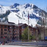
🏔️ Overview
The San Juan Mountains form one of the largest, highest, and most rugged mountain regions in Colorado. Rising across southwestern Colorado and extending into northern New Mexico, they are a major subdivision of the Rocky Mountains and contain a remarkable concentration of high peaks, deep valleys, alpine basins, volcanic formations, and historic mining communities.
Unlike many parts of the Colorado Rockies dominated primarily by uplifted sedimentary or ancient crystalline rock, much of the San Juan landscape was shaped by enormous volcanic eruptions between roughly 35 and 23 million years ago. Calderas, ash-flow deposits, volcanic breccias, lava flows, erosion, and later glaciation combined to create the dramatic terrain seen today.
The range contains numerous summits above 13,000 feet and several famous Colorado fourteeners. Its highest point is Uncompahgre Peak, which rises to approximately 14,315–14,318 feet depending on the elevation dataset and vertical datum used.
Historic towns including Silverton, Ouray, Telluride, Lake City, and Creede developed largely because of the rich mineral deposits found throughout the mountains. Today, the San Juans are equally well known for hiking, climbing, backpacking, skiing, scenic driving, wildlife, wilderness areas, and some of the most spectacular high-country scenery in the American West.
⚡ Fast Facts
| Feature | Details |
|---|---|
| Continent | North America |
| Country | United States |
| States | Primarily Colorado; extending into northern New Mexico |
| Parent Mountain System | Rocky Mountains |
| Highest Peak | Uncompahgre Peak |
| Highest-Peak Elevation | About 14,315–14,318 ft / 4,363–4,364 m |
| Highest-Peak Prominence | About 4,246 ft / 1,294 m |
| Highest-Peak Isolation | About 85.0 mi / 136.8 km |
| Parent Peak of Uncompahgre Peak | Mount Harvard |
| Nearest Higher Neighbor | La Plata Peak |
| Major Wilderness Area | Weminuche Wilderness |
| Geologic Character | Predominantly volcanic, with older crystalline rocks in some areas |
| Notable Towns | Ouray, Silverton, Telluride, Lake City, Creede |
| Major Rivers | Rio Grande, San Juan, Animas, Dolores, Uncompahgre and Gunnison tributaries |
The San Juan Mountains are also included among the major mountain ranges in the United States.

📍 Location
The San Juan Mountains occupy a broad portion of southwestern Colorado, with their southern reaches extending toward northern New Mexico.
The range lies west of the San Luis Valley, which separates much of the San Juans from the Sangre de Cristo Range farther east.
Major communities associated with the mountains include:
- Durango
- Silverton
- Ouray
- Telluride
- Lake City
- Creede
- Pagosa Springs
The Continental Divide crosses the eastern and central portions of the range. Water falling on different sides of the divide ultimately enters very different drainage systems.
The Rio Grande begins in the San Juan high country and flows east toward the San Luis Valley before turning south through New Mexico.
Western portions of the range drain toward the Colorado River system through rivers and tributaries including the San Juan, Dolores, Gunnison, Animas, and Uncompahgre.

📏 Elevation & Major Peaks
The San Juans contain an exceptional concentration of high alpine terrain.
Their highest summit is Uncompahgre Peak, a distinctive mountain near Lake City. Peakbagger currently gives the summit a LiDAR-refined elevation of approximately 14,315.3 feet, while other modern Colorado peak lists commonly use an elevation of approximately 14,318 feet.
The small difference results from the use of different elevation datasets and vertical datums rather than uncertainty over which mountain is the highest in the range.
Uncompahgre Peak has approximately:
- 4,246 feet of prominence
- 85 miles of topographic isolation
- La Plata Peak as its nearest higher neighbor
- Mount Harvard as its line parent
Learn more about why these measurements matter in What Is Mountain Prominence?.
Other famous high summits of the San Juan Mountains include:
- Mount Wilson
- Mount Sneffels
- Wetterhorn Peak
- Handies Peak
- Mount Eolus
- Sunlight Peak
- Windom Peak
- San Luis Peak
- Redcloud Peak
- Sunshine Peak
- Wilson Peak
Mount Wilson is particularly recognizable for its steep slopes and rugged alpine terrain near Telluride.
Uncompahgre Peak also appears among the 10 Highest Peaks in Colorado.
🪨 Geology
The geology of the San Juan Mountains is one of the range’s defining characteristics.
Much of the modern landscape is the deeply eroded remnant of the enormous San Juan volcanic field, which once covered a much larger portion of the southern Rocky Mountains.
Major volcanic activity began roughly 35 million years ago. Early eruptions produced extensive lava flows and volcanic breccias from numerous central volcanoes.
Later activity became increasingly explosive.
Enormous eruptions released vast quantities of volcanic ash and pumice in the form of pyroclastic flows. When magma chambers beneath some volcanic centers were partially emptied, the overlying ground collapsed, producing enormous calderas.
Several major caldera systems survive in the San Juan Mountains, although millions of years of erosion have modified their original forms.
Among them are:
- La Garita Caldera
- Lake City Caldera
- Silverton Caldera
- San Juan Caldera
- Uncompahgre Caldera
- Creede Caldera
- Platoro Caldera
- Bonanza Caldera
The La Garita Caldera is particularly famous because its eruption produced the enormous Fish Canyon Tuff approximately 28 million years ago. It was one of the largest known explosive volcanic eruptions in Earth’s geologic history.
Volcanic activity did not create every part of the range, however.
Areas such as the Needle Mountains expose much older Precambrian crystalline rocks, demonstrating that the San Juans contain a far more complicated geological history than volcanism alone.
Later uplift, rivers, frost weathering, landslides, and repeated Ice Age glaciation cut through the volcanic landscape and produced today’s sharp ridges, cirques, U-shaped valleys, cliffs, and alpine basins.

🌿 Flora & Fauna
Large differences in elevation create several distinct ecological zones across the San Juan Mountains.
Lower and drier areas may contain:
- Pinyon pine
- Juniper
- Ponderosa pine
- Shrublands
- Mountain grasslands
At higher elevations, forests commonly include:
- Douglas fir
- Aspen
- Engelmann spruce
- Subalpine fir
Above the treeline, forests disappear and are replaced by alpine tundra.
Plants living here must survive a short growing season, powerful winds, intense ultraviolet radiation, freezing nighttime temperatures, and deep winter snow. Wildflowers can nevertheless produce striking displays during the brief alpine summer.
Wildlife found across the greater San Juan region includes:
- Elk
- Mule deer
- Rocky Mountain bighorn sheep
- Black bears
- Mountain lions
- Coyotes
- Marmots
- Pikas
- Snowshoe hares
- Golden eagles
- Numerous smaller mammals and alpine birds
The Weminuche Wilderness provides especially extensive high-elevation habitat. The Forest Service identifies several Rocky Mountain bighorn sheep herds within the region.
🥾 Hiking & Climbing Routes
The San Juan Mountains offer everything from short alpine walks to demanding multi-day wilderness expeditions and difficult mountaineering routes.
Uncompahgre Peak
Uncompahgre Peak is one of the most popular major summit objectives.
Its standard route is generally considered a Class 2 hike under normal dry summer conditions. Reaching the upper Nellie Creek trailhead, however, has traditionally required driving a rough road that may demand a high-clearance four-wheel-drive vehicle.
Weminuche Wilderness
The Weminuche Wilderness is one of the premier backpacking destinations in the Colorado Rockies.
At approximately 499,771 acres, it is the largest federally designated Wilderness area in Colorado.
It includes extensive trail networks, remote valleys, alpine lakes, high passes, and rugged peaks. Portions of both the Continental Divide Trail and Colorado Trail pass through the broader region.
Continental Divide Trail
The Continental Divide Trail follows high terrain through parts of the San Juans and provides some of the most dramatic long-distance backpacking scenery in Colorado.
Sections can be exceptionally remote, with limited road access and long distances between resupply points.
Fourteener Climbing
Several San Juan fourteeners can be reached primarily by hiking and scrambling, while others require significantly greater mountaineering skill.
Mountains such as Mount Wilson and other peaks in the Wilson group can involve steep, loose, exposed terrain where route-finding and climbing experience are important.
A mountain’s elevation should never be used as a measure of technical difficulty.
🏔️ Field Guide Tip: Summer thunderstorms are a major hazard in the San Juans. Begin high-elevation hikes early, monitor the forecast carefully, and plan to descend exposed ridges and summits before afternoon storms develop. Carry the Ten Essentials for Hiking and verify trail, road, wildfire, and land-access conditions before departure.

⛏️ Mining History
Mining played an enormous role in the development of the San Juan Mountains.
The same volcanic and hydrothermal processes responsible for much of the range’s unusual geology also concentrated valuable metals into mineralized veins.
Gold and silver discoveries during the 19th century attracted prospectors and mining companies into terrain that was exceptionally difficult to access.
Mining settlements developed into towns such as:
- Silverton
- Ouray
- Telluride
- Lake City
- Creede
Roads, railroads, tunnels, mills, and mining camps were constructed throughout the mountains.
Many modern backcountry roads follow routes originally built to connect mines and settlements.
Mining declined substantially during the 20th century, but its physical legacy remains highly visible. Abandoned mines, historic structures, tailings, tunnels, and ghost towns can still be found across portions of the region.
Old mine workings can be unstable and dangerous. Visitors should never enter abandoned mines or trespass on private mining claims.
🌤️ Best Time to Visit
The best season depends heavily on the activity.
Summer
July through September is generally the main season for high-elevation hiking and climbing.
By midsummer, many high trails have become largely free of seasonal snow. Alpine wildflowers can also be impressive.
Afternoon thunderstorms are common, making early starts important.
Autumn
September and early October can bring cool temperatures, clearer weather, and spectacular displays of golden aspen.
Snowstorms can arrive early at high elevation, however.
Winter
Winter transforms the San Juans into a major skiing and snow-recreation region.
The mountains can receive deep snowfall, but steep slopes also create serious avalanche terrain. Backcountry winter travel requires appropriate training, equipment, and current avalanche information.
Spring
Spring is often one of the most complicated seasons for mountain travel.
High trails may remain buried under snow even while lower valleys are warm. Snowmelt can make roads muddy or impassable, and avalanche hazards can persist at higher elevations.

🧭 Nearby Mountains & Attractions
San Juan Skyway
The San Juan Skyway is one of Colorado’s best-known scenic driving routes.
The loop connects communities including Durango, Silverton, Ouray, Telluride, Dolores, and Cortez while passing through dramatic mountain scenery.
Million Dollar Highway
The spectacular highway between Silverton and Ouray is commonly called the Million Dollar Highway.
The road crosses steep mountain terrain and provides access to portions of the western San Juans.
Durango & Silverton Narrow Gauge Railroad
The historic railway between Durango and Silverton follows the Animas River through rugged mountain country and preserves an important connection to the area’s mining and transportation history.
Telluride
Telluride occupies a dramatic valley surrounded by steep San Juan peaks.
The former mining settlement has developed into an internationally known mountain resort while retaining much of its historic architecture.
Ouray
Ouray sits within an exceptionally steep mountain setting and is often referred to as the “Switzerland of America.”
The surrounding area provides access to hiking trails, waterfalls, hot springs, historic mining roads, and high mountain passes.
San Luis Valley
East of the San Juans lies the enormous San Luis Valley.
Across the valley rise the steep peaks of the Sangre de Cristo Range, creating one of Colorado’s most dramatic large-scale mountain landscapes.

💡 Fun Facts
- The San Juan Mountains contain the largest federally designated Wilderness area in Colorado: the Weminuche Wilderness.
- The range preserves the remains of one of the largest ancient volcanic fields in North America.
- The La Garita volcanic system produced one of the largest known explosive eruptions in Earth’s geological record.
- Uncompahgre Peak is the highest mountain in the San Juans and one of the highest peaks in Colorado.
- Numerous present-day recreational roads began as transportation routes serving mines and mining settlements.
- The headwaters of the Rio Grande are located within the San Juan Mountains.
- Despite their volcanic appearance and origin, the famous San Juan summits are not modern active volcanoes. They are eroded remnants of an ancient volcanic landscape.
❓ Frequently Asked Questions
Where are the San Juan Mountains?
The San Juan Mountains are located primarily in southwestern Colorado, with the larger geographic mountain region extending toward northern New Mexico. They form part of the Southern Rocky Mountains.
What is the highest mountain in the San Juan Mountains?
Uncompahgre Peak is the highest summit in the range. Modern datasets place its elevation at approximately 14,315–14,318 feet.
Are the San Juan Mountains volcanic?
Much of the range consists of volcanic rocks produced by enormous eruptions between approximately 35 and 23 million years ago. The modern mountains are heavily eroded remnants of this ancient volcanic field rather than active volcanoes.
What towns are in the San Juan Mountains?
Important communities include Silverton, Ouray, Telluride, Lake City, and Creede. Durango and Pagosa Springs also provide major gateways to the region.
Are there fourteeners in the San Juan Mountains?
Yes. The range contains numerous summits above 14,000 feet, including Uncompahgre Peak, Mount Wilson, Mount Sneffels, Wetterhorn Peak, Handies Peak, Mount Eolus, Windom Peak, Sunlight Peak, and San Luis Peak.
What is the largest wilderness area in the San Juan Mountains?
The Weminuche Wilderness covers approximately 499,771 acres and is the largest designated Wilderness area in Colorado.
Can you hike in the San Juan Mountains?
Yes. The range contains hundreds of miles of trails ranging from relatively short hikes to remote backpacking routes and difficult summit climbs.
What is the best time to hike in the San Juan Mountains?
July through September is generally the most reliable period for high-elevation hiking, although snow, thunderstorms, wildfire conditions, road closures, and early autumn storms can affect access.
Why are the San Juan Mountains so rugged?
Their rugged appearance reflects a combination of ancient volcanism, regional uplift, river erosion, frost weathering, landslides, and repeated glaciation during the Ice Ages.

🔗 Related Articles
- Uncompahgre Peak
- Mount Wilson, Colorado
- The 10 Highest Peaks in Colorado
- Rocky Mountains
- Sangre de Cristo Range
- Mountain Ranges in the U.S.
- What Is Mountain Prominence?
🔗 Related Hiking and Safety Guides
📚 Sources
- U.S. Geological Survey — Geologic Map of the Central San Juan Caldera Cluster
- Colorado Geological Survey — Geology of the Western San Juan Mountains and San Juan Skyway
- USDA Forest Service — San Juan National Forest
- USDA Forest Service — Weminuche Wilderness
- Peakbagger — Uncompahgre Peak